Slovenské Nové Mesto
Slovenské Nové Mesto
Slovenské Nové Mesto | |
|---|---|
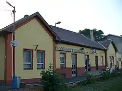 Train station in Slovenské Nové Mesto | |
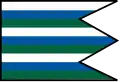 Flag | |
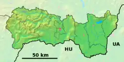 Slovenské Nové Mesto Location of Slovenské Nové Mesto in the Košice Region  Slovenské Nové Mesto Location of Slovenské Nové Mesto in Slovakia | |
| Coordinates: 48°24′N 21°40′E / 48.40°N 21.67°E | |
| Country | |
| Region | |
| District | Trebišov District |
| First mentioned | 1918 |
| Government | |
| • Mayor | Ján Kalinič |
| Area | |
• Total | 13.38 km2 (5.17 sq mi) |
| Elevation | 102 m (335 ft) |
| Population (2021)[3] | |
• Total | 1,074 |
| Time zone | UTC+1 (CET) |
| • Summer (DST) | UTC+2 (CEST) |
| Postal code | 763 3[2] |
| Area code | +421 56[2] |
| Car plate | TV |
Slovenské Nové Mesto (Hungarian: Újhely, Kisújhely, Szlovákújhely or Tótújhely) is a village and municipality in the Trebišov District in the Košice Region of south-eastern Slovakia.
History
The village is a former suburb of the Hungarian city of Sátoraljaújhely, which was separated from the rest of the city by the border of the newly created Czechoslovakia in 1920. The Košice - Mukacheve railway-line made the village strategically important.
Geography
The village lies at an altitude of 104 metres and covers an area of 13.382 km². It has a population of about 1060 people
Ethnicity
The village is about 87% Slovak and 13% Hungarian
Politics
The present mayor is Ján Kalinič.
Facilities
The village has a public library and a football pitch.
References
- ^ "Hustota obyvateľstva - obce [om7014rr_ukaz: Rozloha (Štvorcový meter)]". www.statistics.sk (in Slovak). Statistical Office of the Slovak Republic. 2022-03-31. Retrieved 2022-03-31.
- ^ a b c "Základná charakteristika". www.statistics.sk (in Slovak). Statistical Office of the Slovak Republic. 2015-04-17. Retrieved 2022-03-31.
- ^ "Počet obyvateľov podľa pohlavia - obce (ročne)". www.statistics.sk (in Slovak). Statistical Office of the Slovak Republic. 2022-03-31. Retrieved 2022-03-31.