Černá Voda
Černá Voda | |
|---|---|
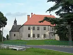 Černá Voda Castle | |
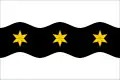 Flag 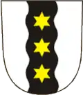 Coat of arms | |
 Černá Voda Location in the Czech Republic | |
| Coordinates: 50°18′30″N 17°8′49″E / 50.30833°N 17.14694°E | |
| Country | |
| Region | Olomouc |
| District | Jeseník |
| First mentioned | 1284 |
| Area | |
• Total | 9.97 km2 (3.85 sq mi) |
| Elevation | 340 m (1,120 ft) |
| Population (2025-01-01)[1] | |
• Total | 539 |
| • Density | 54/km2 (140/sq mi) |
| Time zone | UTC+1 (CET) |
| • Summer (DST) | UTC+2 (CEST) |
| Postal code | 790 54 |
| Website | www |
Černá Voda (German: Schwarzwasser) is a municipality and village in Jeseník District in the Olomouc Region of the Czech Republic. It has about 500 inhabitants.
Černá Voda lies approximately 9 kilometres (6 mi) north of Jeseník, 80 km (50 mi) north of Olomouc, and 197 km (122 mi) east of Prague.
Demographics
| Year | Pop. | ±% |
|---|---|---|
| 1869 | 1,953 | — |
| 1880 | 2,089 | +7.0% |
| 1890 | 2,049 | −1.9% |
| 1900 | 2,159 | +5.4% |
| 1910 | 2,147 | −0.6% |
| 1921 | 1,979 | −7.8% |
| 1930 | 2,182 | +10.3% |
| 1950 | 1,030 | −52.8% |
| 1961 | 946 | −8.2% |
| 1970 | 877 | −7.3% |
| 1980 | 781 | −10.9% |
| 1991 | 645 | −17.4% |
| 2001 | 665 | +3.1% |
| 2011 | 586 | −11.9% |
| 2021 | 516 | −11.9% |
| Source: Censuses[2][3] | ||
References
- ^ "Population of Municipalities – 1 January 2025". Czech Statistical Office. 2025-05-16.
- ^ "Historický lexikon obcí České republiky 1869–2011" (in Czech). Czech Statistical Office. 2015-12-21.
- ^ "Population Census 2021: Population by sex". Public Database. Czech Statistical Office. 2021-03-27.
External links
Wikimedia Commons has media related to Černá Voda.