Ōrere Point
Ōrere Point | |
|---|---|
Rural settlement | |
 Orere Point General Store | |
| Coordinates: 36°58′S 175°15′E / 36.967°S 175.250°E | |
| Country | New Zealand |
| Region | Auckland Region |
| Ward | Franklin ward |
| Board | Franklin Local Board |
| Electorates | |
| Government | |
| • Territorial authority | Auckland Council |
| Area | |
• Total | 0.80 km2 (0.31 sq mi) |
| Population (June 2024)[2] | |
• Total | 390 |
| • Density | 490/km2 (1,300/sq mi) |
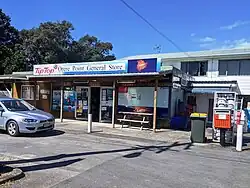
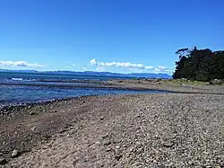
Ōrere Point is a rural township in the Auckland Region. It is located on the Hauraki Gulf just outside the Auckland metropolitan area. Facilities include a local store, playground, campground, picnic area, parking and limited mobility toilets. Activities include wild life watching, fishing and swimming.[3]
The name was altered to include a macron in 2019.[4]
Demographics
Ōrere Point is defined by Statistics New Zealand as a rural settlement. It covers 0.80 km2 (0.31 sq mi)[1] and had an estimated population of 390 as of June 2024,[2] with a population density of 488 people per km2. It is part of the larger Kawakawa Bay-Orere statistical area.[5]
| Year | Pop. | ±% p.a. |
|---|---|---|
| 2006 | 324 | — |
| 2013 | 288 | −1.67% |
| 2018 | 345 | +3.68% |
| 2023 | 390 | +2.48% |
| Source: [6][7] | ||
Ōrere Point had a population of 390 in the 2023 New Zealand census, an increase of 45 people (13.0%) since the 2018 census, and an increase of 102 people (35.4%) since the 2013 census. There were 210 males and 180 females in 192 dwellings.[8] 3.1% of people identified as LGBTIQ+. The median age was 54.7 years (compared with 38.1 years nationally). There were 48 people (12.3%) aged under 15 years, 33 (8.5%) aged 15 to 29, 186 (47.7%) aged 30 to 64, and 123 (31.5%) aged 65 or older.[7]
People could identify as more than one ethnicity. The results were 89.2% European (Pākehā), 23.8% Māori, 8.5% Pasifika, 1.5% Asian, and 2.3% other, which includes people giving their ethnicity as "New Zealander". English was spoken by 98.5%, Māori language by 4.6%, Samoan by 0.8%, and other languages by 6.2%. No language could be spoken by 0.8% (e.g. too young to talk). The percentage of people born overseas was 14.6, compared with 28.8% nationally.[7]
Religious affiliations were 33.8% Christian, 2.3% Māori religious beliefs, 0.8% New Age, and 0.8% other religions. People who answered that they had no religion were 53.1%, and 9.2% of people did not answer the census question.[7]
Of those at least 15 years old, 54 (15.8%) people had a bachelor's or higher degree, 180 (52.6%) had a post-high school certificate or diploma, and 111 (32.5%) people exclusively held high school qualifications. The median income was $33,200, compared with $41,500 nationally. 21 people (6.1%) earned over $100,000 compared to 12.1% nationally. The employment status of those at least 15 was that 132 (38.6%) people were employed full-time, 48 (14.0%) were part-time, and 12 (3.5%) were unemployed.[7]
Education
Ōrere School is a coeducational full primary school (years 1–8) with a roll of 33 as of July 2025.[9][10] The school was founded in 1890, and held a reunion in 2015 to celebrate 125 years.[11]
Climate
| Climate data for Orere Point (1951–1980) | |||||||||||||
|---|---|---|---|---|---|---|---|---|---|---|---|---|---|
| Month | Jan | Feb | Mar | Apr | May | Jun | Jul | Aug | Sep | Oct | Nov | Dec | Year |
| Mean daily maximum °C (°F) | 23.4 (74.1) |
24.4 (75.9) |
22.6 (72.7) |
19.7 (67.5) |
16.8 (62.2) |
15.1 (59.2) |
14.0 (57.2) |
14.7 (58.5) |
16.0 (60.8) |
17.9 (64.2) |
19.7 (67.5) |
21.6 (70.9) |
18.8 (65.9) |
| Daily mean °C (°F) | 18.4 (65.1) |
19.3 (66.7) |
18.0 (64.4) |
15.3 (59.5) |
12.7 (54.9) |
11.0 (51.8) |
9.9 (49.8) |
10.5 (50.9) |
12.3 (54.1) |
14.0 (57.2) |
15.5 (59.9) |
17.1 (62.8) |
14.5 (58.1) |
| Mean daily minimum °C (°F) | 13.4 (56.1) |
14.1 (57.4) |
13.4 (56.1) |
10.9 (51.6) |
8.5 (47.3) |
6.8 (44.2) |
5.7 (42.3) |
6.3 (43.3) |
8.6 (47.5) |
10.0 (50.0) |
11.3 (52.3) |
12.5 (54.5) |
10.1 (50.2) |
| Average rainfall mm (inches) | 72 (2.8) |
99 (3.9) |
69 (2.7) |
101 (4.0) |
109 (4.3) |
77 (3.0) |
113 (4.4) |
118 (4.6) |
104 (4.1) |
89 (3.5) |
91 (3.6) |
87 (3.4) |
1,129 (44.3) |
| Source: NIWA[12] | |||||||||||||
References
- ^ a b "Stats NZ Geographic Data Service". Urban Rural 2023 (generalised). Retrieved 16 February 2025.
- ^ a b "Aotearoa Data Explorer". Statistics New Zealand. Retrieved 26 October 2024.
- ^ Guide, The Swim. "Orere Point Beach". Swim Guide. Retrieved 3 February 2020.
- ^ "Notice of Approved Official Geographic Names". New Zealand Gazette. 21 June 2019.
- ^ 2018 Census place summary: Kawakawa Bay-Orere
- ^ "Statistical area 1 dataset for 2018 Census". Statistics New Zealand. March 2020. 7007096, 7007097 and 7007098.
- ^ a b c d e "Totals by topic for individuals, (RC, TALB, UR, SA3, SA2, Ward, Health), 2013, 2018, and 2023 Censuses". Stats NZ – Tatauranga Aotearoa – Aotearoa Data Explorer. Ōrere Point (1126). Retrieved 3 October 2024.
- ^ "Totals by topic for dwellings, (RC, TALB, UR, SA3, SA2, Ward, Health), 2013, 2018, and 2023 Censuses". Stats NZ – Tatauranga Aotearoa – Aotearoa Data Explorer. Retrieved 3 October 2024.
- ^ "New Zealand Schools Directory". New Zealand Ministry of Education. Retrieved 1 July 2025.
- ^ Education Counts: Orere School
- ^ "Old schools pals meet for milestone". Papakura Courier. 31 August 2015.
- ^ "CliFlo -The National Climate Database (Agent number: 1958)". NIWA. Retrieved 13 September 2024.
External links