Řitonice
Řitonice | |
|---|---|
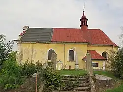 Church of Saint Stephan | |
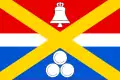 Flag 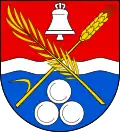 Coat of arms | |
 Řitonice Location in the Czech Republic | |
| Coordinates: 50°24′30″N 15°6′29″E / 50.40833°N 15.10806°E | |
| Country | |
| Region | Central Bohemian |
| District | Mladá Boleslav |
| First mentioned | 1352 |
| Area | |
• Total | 1.66 km2 (0.64 sq mi) |
| Elevation | 255 m (837 ft) |
| Population (2025-01-01)[1] | |
• Total | 86 |
| • Density | 52/km2 (130/sq mi) |
| Time zone | UTC+1 (CET) |
| • Summer (DST) | UTC+2 (CEST) |
| Postal code | 294 04 |
| Website | www |
Řitonice is a municipality and village in Mladá Boleslav District in the Central Bohemian Region of the Czech Republic. It has about 90 inhabitants.
Demographics
| Year | Pop. | ±% |
|---|---|---|
| 1869 | 205 | — |
| 1880 | 201 | −2.0% |
| 1890 | 195 | −3.0% |
| 1900 | 153 | −21.5% |
| 1910 | 165 | +7.8% |
| 1921 | 159 | −3.6% |
| 1930 | 151 | −5.0% |
| 1950 | 110 | −27.2% |
| 1961 | 115 | +4.5% |
| 1970 | 92 | −20.0% |
| 1980 | 87 | −5.4% |
| 1991 | 76 | −12.6% |
| 2001 | 69 | −9.2% |
| 2011 | 91 | +31.9% |
| 2021 | 79 | −13.2% |
| Source: Censuses[2][3] | ||
References
- ^ "Population of Municipalities – 1 January 2025". Czech Statistical Office. 2025-05-16.
- ^ "Historický lexikon obcí České republiky 1869–2011" (in Czech). Czech Statistical Office. 2015-12-21.
- ^ "Population Census 2021: Population by sex". Public Database. Czech Statistical Office. 2021-03-27.
External links
Wikimedia Commons has media related to Řitonice.