Šakiai District Municipality
Šakiai District Municipality
Šakių rajono savivaldybė | |
|---|---|
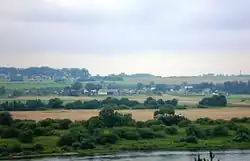 Landscape near Mikytai | |
 Flag  Coat of arms | |
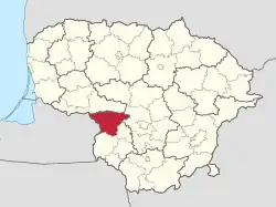 Location of Šakiai district municipality within Lithuania | |
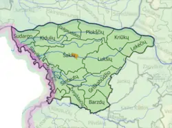 Map of Šakiai district municipality | |
| Country | |
| Ethnographic region | Suvalkija |
| County | |
| Capital | Šakiai |
| Elderships | 14 |
| Area | |
• Total | 1,453 km2 (561 sq mi) |
| • Rank | 17th |
| Population (2021[1]) | |
• Total | 26,931 |
| • Rank | 29th |
| • Density | 19/km2 (48/sq mi) |
| • Rank | 39-40th |
| Time zone | UTC+2 (EET) |
| • Summer (DST) | UTC+3 (EEST) |
| Telephone code | 345 |
| Major settlements |
|
| Website | www |
Šakiai District Municipality is one of 60 municipalities in Lithuania.
with Vladislavov at the top
References
- ^ "Gyventojai gyvenamosiose vietovėse" [Residents in residential areas] (in Lithuanian). Archived from the original on 2022-01-26.
External links
| Municipalities |  | |
|---|---|---|
| Cities | ||
| Towns | ||
| Villages | ||
54°56′06″N 23°06′04″E / 54.93500°N 23.10111°E