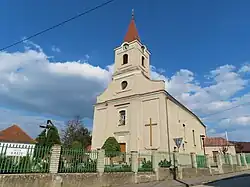
Žitavany
Žitavany
Zsitvaapáti | |
|---|---|
 | |
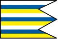 Flag | |
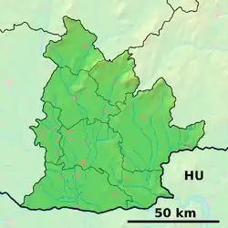 Žitavany Location of Žitavany in the Nitra Region  Žitavany Location of Žitavany in Slovakia | |
| Coordinates: 48°24′N 18°25′E / 48.40°N 18.42°E | |
| Country | |
| Region | |
| District | Zlaté Moravce District |
| First mentioned | 1075 |
| Area | |
• Total | 18.20 km2 (7.03 sq mi) |
| Elevation | 204 m (669 ft) |
| Population (2021)[3] | |
• Total | 1,825 |
| Time zone | UTC+1 (CET) |
| • Summer (DST) | UTC+2 (CEST) |
| Postal code | 951 97[2] |
| Area code | +421 37[2] |
| Car plate | ZM |
| Website | www |
Žitavany (Hungarian: Zsitvaapáti) is a village and municipality in Zlaté Moravce District of the Nitra Region, in western-central Slovakia. The municipality had 1874 inhabitants in 2011.[4]
References
- ^ "Hustota obyvateľstva - obce [om7014rr_ukaz: Rozloha (Štvorcový meter)]". www.statistics.sk (in Slovak). Statistical Office of the Slovak Republic. 31 March 2022. Retrieved 31 March 2022.
- ^ a b c "Základná charakteristika". www.statistics.sk (in Slovak). Statistical Office of the Slovak Republic. 17 April 2015. Retrieved 31 March 2022.
- ^ "Počet obyvateľov podľa pohlavia - obce (ročne)". www.statistics.sk (in Slovak). Statistical Office of the Slovak Republic. 31 March 2022. Retrieved 31 March 2022.
- ^ "Permanent Resident Population" (PDF) (in Slovak). pp. 167–168. Archived from the original (PDF) on 1 August 2014. Retrieved 10 August 2023.