A62 road
 | ||||
|---|---|---|---|---|
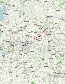 Click map to enlarge | ||||
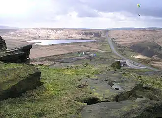 Standedge seen from the top of nearby Pule Hill. Standedge cutting and Redbrook Reservoir can be seen | ||||
| Route information | ||||
| Length | 38.6 mi[1] (62.1 km) | |||
| Major junctions | ||||
| West end | 53°29′06″N 2°13′58″W / 53.4849°N 2.2327°W | |||
| East end | 53°47′16″N 1°34′15″W / 53.7878°N 1.5709°W | |||
| Location | ||||
| Country | United Kingdom | |||
| Counties | Greater Manchester West Yorkshire | |||
| Primary destinations | Oldham Huddersfield Liversedge | |||
| Road network | ||||
| ||||
The A62 road in Northern England runs between the cities of Leeds in West Yorkshire and Manchester in Greater Manchester covering a distance of 38.5 miles (62.0 km). It passes through Heckmondwike, Huddersfield, Oldham and Failsworth, the highest part of the motorway is in the Pennines
Route
The A62 begins at a junction with the A58 road as Gelderd Road in Leeds. It runs through West Yorkshire, passing through Birstall, Heckmondwike, Liversedge, Huddersfield, Linthwaite, Slaithwaite, and Marsden. It crosses the Pennines at Standedge, and continues through Saddleworth and into Oldham. From there, the A62 runs into Manchester as Oldham Street and Oldham Road through Failsworth, ending at the Manchester Inner Ring Road.
History
It is paralleled at some distance by part of the M62 Trans-Pennine motorway. Before the M62 was built, the A62 was the main trans-Pennine road between Oldham and Huddersfield. The M62 is numbered after the A62 and now takes most of the long-distance traffic between Manchester and Leeds (2023 Average daily traffic figures: M62: 110,000 [2] A62: 5,885 [3].)
Junction list
| County | Location | mi[1] | km | Destinations | Notes |
|---|---|---|---|---|---|
| Greater Manchester | Manchester | 0.0 | 0.0 | Western terminus | |
| 1.2 | 1.9 | Queens Road / Hulme Hall Lane (A6010) – Cheetham Hill, Harpurhey, Collyhurst, Clayton, Beswick | Destinations signed westbound only | ||
| Failsworth | 3.0 | 4.8 | To M62, M60 and Leeds signed eastbound only; southern terminus of A663 | ||
| Failsworth– Oldham– Chadderton boundary | 4.4– 4.6 | 7.1– 7.4 | M60 junction 22 | ||
| Oldham | 5.8 | 9.3 | No access from A62 west to A6048; southern terminus of A6048 | ||
| 6.2 | 10.0 | To A669 and Chadderton signed eastbound only; western terminus of A627 / A669 concurrency | |||
| 6.3– 6.7 | 10.1– 10.8 | Junction; no eastbound entrance; eastern terminus of A627 concurrency | |||
| 7.2 | 11.6 | Westbound access via B6194; Stalybridge signed westbound only | |||
| 7.8 | 12.6 | Saddleworth signed westbound only; southwestern terminus of A672 | |||
| Delph | 11.5 | 18.5 | Brief concurrency | ||
| Diggle | 13.3 | 21.4 | Saddleworth signed westbound only; northern terminus of A670 | ||
| West Yorkshire | Huddersfield | 24.3 | 39.1 | A629, To M1, Wakefield and Sheffield signed northbound only, To A6024 and Meltham southbound only; southern terminus of A629 concurrency | |
| 24.5 | 39.4 | Eastern terminus of A640 | |||
| 24.6– 24.8 | 39.6– 39.9 | Junction; eastern terminus of A629 concurrency | |||
| 25.1 | 40.4 | Southern terminus of A641 | |||
| 25.2 | 40.6 | To M1, A642, A629, Oldham, Wakefield and Sheffield signed westbound only, Kingsgate eastbound only | |||
| Bradley | 28.1 | 45.2 | To M62, B6118 and Elland signed westbound only; eastern terminus of A6107 | ||
| Calderdale– Mirfield boundary | 28.5 | 45.9 | Western terminus of A644 concurrency | ||
| Mirfield | 28.8 | 46.3 | Ravensthorpe signed eastbound only; eastern terminus of A644 concurrency | ||
| Liversedge | 31.2 | 50.2 | To A638, Batley, Dewsbury and H'wike signed eastbound only | ||
| 31.3 | 50.4 | A638, Dewsbury, Bradford and H'wike signed westbound only | |||
| Heckmondwike | 31.8 | 51.2 | Southern terminus of A651 | ||
| Birstall | 33.0 | 53.1 | |||
| 33.2 | 53.4 | ||||
| Birstall– Gildersome boundary | 34.5– 34.9 | 55.5– 56.2 | M62 junction 27 | ||
| Leeds | 37.7 | 60.7 | Huddersfield signed westbound only | ||
| 38.6 | 62.1 | Eastern terminus | |||
| 1.000 mi = 1.609 km; 1.000 km = 0.621 mi | |||||
References
- ^ a b "Habib Allied International Bank PLC, 2 Swan St, Manchester M4 5JN, United Kingdom to Huddersfield HD1 4BU, UK to Gelderd Rd, Holbeck, Leeds LS12 6HJ, UK". Google Maps. Retrieved 24 July 2025.
- ^ [M62|https://roadtraffic.dft.gov.uk/manualcountpoints/6054]
- ^ [A62|https://roadtraffic.dft.gov.uk/manualcountpoints/77649]
External links
A roads in Zone 6 of the Great Britain road numbering scheme | ||
|---|---|---|