Afton Township, Ward County, North Dakota
Afton Township, North Dakota | |
|---|---|
 Afton Township, North Dakota Location within the state of North Dakota | |
| Coordinates: 48°10′3″N 101°20′18″W / 48.16750°N 101.33833°W | |
| Country | United States |
| State | North Dakota |
| County | Ward |
| Area | |
• Total | 35.8 sq mi (92.8 km2) |
| • Land | 35.7 sq mi (92.4 km2) |
| • Water | 0.2 sq mi (0.4 km2) |
| Elevation | 1,850 ft (564 m) |
| Population (2000) | |
• Total | 515 |
| • Density | 14.4/sq mi (5.6/km2) |
| Time zone | UTC-6 (Central (CST)) |
| • Summer (DST) | UTC-5 (CDT) |
| Area code | 701 |
| FIPS code | 38-00740[1] |
| GNIS feature ID | 1036992[2] |
Afton Township is a township in Ward County, North Dakota, United States.
References
- ^ "U.S. Census website". United States Census Bureau. Retrieved January 31, 2008.
- ^ "US Board on Geographic Names". United States Geological Survey. October 25, 2007. Retrieved January 31, 2008.
Municipalities and communities of Ward County, North Dakota, United States | ||
|---|---|---|
| Cities | 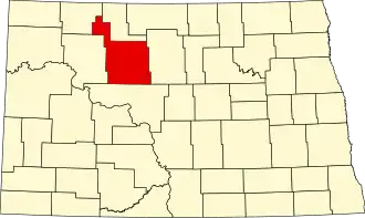 | |
| Townships |
| |
| CDPs | ||
| Other community | ||
| Indian reservation | ||
| Footnotes | ‡This populated place also has portions in an adjacent county or counties | |