Ah-gwah-ching, Minnesota
Ah-gwah-ching | |
|---|---|
 Ah-gwah-ching Location of Ah-gwah-ching within Cass County  Ah-gwah-ching Ah-gwah-ching (the United States) | |
| Coordinates: 47°04′27″N 94°33′46″W / 47.07417°N 94.56278°W | |
| Country | United States |
| State | Minnesota |
| County | Cass |
| Township | Shingobee Township |
| Elevation | 1,335 ft (407 m) |
| Time zone | UTC-6 (Central (CST)) |
| • Summer (DST) | UTC-5 (CDT) |
| ZIP code | 56430 |
| Area code | 218 |
| GNIS feature ID | 659097[1] |
Ah-gwah-ching is an unincorporated community in Shingobee Township, Cass County, Minnesota, United States, near Walker.
It is along State Highways 200 (MN 200) and 371 (MN 371), two miles south-southeast of Walker. Ah-gwah-ching has the ZIP code 56430.[2]
The name Ah-gwah-ching means "out-of-doors" in the Ojibwe language.
References
Municipalities and communities of Cass County, Minnesota, United States | ||
|---|---|---|
| Cities | 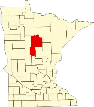 | |
| Townships |
| |
| Unorganized territories | ||
| CDP | ||
| Unincorporated communities | ||
| Indian reservation | ||
| Ghost town | ||
| Footnotes | ‡This populated place also has portions in an adjacent county or counties | |