Algeciras, Huila
Algeciras, Huila | |
|---|---|
Municipality and town | |
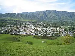 Panoramic view of Algeciras | |
.svg.png) Flag | |
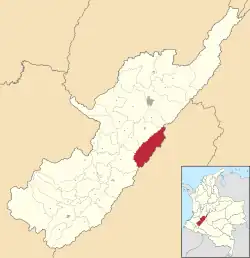 Location of the municipality and town of Algeciras, Huila in the Córdoba Department of Colombia. | |
| Country | |
| Department | Huila Department |
| Founded | February 10, 1824 |
| Government | |
| • Mayor | Javier Rivera Cortes |
| Area | |
• Total | 567.7 km2 (219.19 sq mi) |
| Elevation | 1,528 m (5,013.15 ft) |
| Population (2015) | |
• Total | 24,499 |
| • Density | 43.15/km2 (111.77/sq mi) |
| Time zone | UTC-5 (Colombia Standard Time) |
Algeciras (Spanish pronunciation: [alxeˈsiɾas]) is a town and municipality in the Huila Department, Colombia.
Climate
| Climate data for Algeciras, elevation 1,155 m (3,789 ft), (1981–2010) | |||||||||||||
|---|---|---|---|---|---|---|---|---|---|---|---|---|---|
| Month | Jan | Feb | Mar | Apr | May | Jun | Jul | Aug | Sep | Oct | Nov | Dec | Year |
| Mean daily maximum °C (°F) | 29.6 (85.3) |
29.9 (85.8) |
29.3 (84.7) |
29.0 (84.2) |
29.4 (84.9) |
29.7 (85.5) |
29.8 (85.6) |
30.6 (87.1) |
30.6 (87.1) |
29.9 (85.8) |
28.4 (83.1) |
28.6 (83.5) |
29.6 (85.3) |
| Daily mean °C (°F) | 23.2 (73.8) |
23.5 (74.3) |
23.4 (74.1) |
23.1 (73.6) |
23.2 (73.8) |
23.1 (73.6) |
23.0 (73.4) |
23.3 (73.9) |
23.4 (74.1) |
23.3 (73.9) |
22.9 (73.2) |
23.0 (73.4) |
23.2 (73.8) |
| Mean daily minimum °C (°F) | 17.7 (63.9) |
17.9 (64.2) |
18.1 (64.6) |
18.1 (64.6) |
18.3 (64.9) |
17.7 (63.9) |
17.1 (62.8) |
17.1 (62.8) |
17.0 (62.6) |
17.7 (63.9) |
18.2 (64.8) |
17.9 (64.2) |
17.7 (63.9) |
| Average precipitation mm (inches) | 82.1 (3.23) |
75.5 (2.97) |
119.7 (4.71) |
110.4 (4.35) |
106.1 (4.18) |
70.6 (2.78) |
54.8 (2.16) |
45.7 (1.80) |
54.1 (2.13) |
135.8 (5.35) |
148.3 (5.84) |
107.8 (4.24) |
1,106.4 (43.56) |
| Average precipitation days | 13 | 12 | 17 | 20 | 21 | 19 | 17 | 15 | 15 | 20 | 18 | 16 | 201 |
| Average relative humidity (%) | 76 | 75 | 77 | 79 | 78 | 76 | 73 | 69 | 70 | 73 | 79 | 79 | 75 |
| Mean monthly sunshine hours | 155.0 | 112.9 | 111.6 | 108.0 | 117.8 | 105.0 | 117.8 | 124.0 | 117.0 | 117.8 | 117.0 | 139.5 | 1,443.4 |
| Mean daily sunshine hours | 5.0 | 4.0 | 3.6 | 3.6 | 3.8 | 3.5 | 3.8 | 4.0 | 3.9 | 3.8 | 3.9 | 4.5 | 4.0 |
| Source: Instituto de Hidrologia Meteorologia y Estudios Ambientales[1] | |||||||||||||
References
- ^ "Promedios Climatológicos 1981–2010" (in Spanish). Instituto de Hidrologia Meteorologia y Estudios Ambientales. Archived from the original on 15 August 2016. Retrieved 17 June 2024.
Municipalities in Huila Department | ||
|---|---|---|
2°32′N 75°19′W / 2.533°N 75.317°W