Amaya, Texas
Amaya, Texas | |
|---|---|
| Coordinates: 28°42′50″N 99°50′9″W / 28.71389°N 99.83583°W | |
| Country | United States |
| State | Texas |
| County | Zavala |
| Area | |
• Total | 0.2 sq mi (0.5 km2) |
| • Land | 0.2 sq mi (0.5 km2) |
| • Water | 0.0 sq mi (0 km2) |
| Population (2020) | |
• Total | 108 |
| • Density | 540/sq mi (210/km2) |
| Time zone | UTC-6 (Central (CST)) |
| • Summer (DST) | UTC-5 (CDT) |
| Zip Code | 78839 |
| FIPS code | 4803008 |
Amaya is a census-designated place (CDP) in Zavala County, Texas, United States. This was a new CDP formed from parts of the former Las Colonias CDP prior to the 2010 census with a population of 93.[1]
Geography
Amaya is located at 28°42′50″N 99°50′9″W / 28.71389°N 99.83583°W (28.713886, -99.835838). The CDP has a total area of 0.2 square miles (0.52 km2), all land.[2]
Demographics
| Census | Pop. | Note | %± |
|---|---|---|---|
| 2010 | 93 | — | |
| 2020 | 108 | 16.1% | |
| U.S. Decennial Census[3] 1850–1900[4] 1910[5] 1920[6] 1930[7] 1940[8] 1950[9] 1960[10] 1970[11] 1980[12] 1990[13] 2000[14] 2010[15] 2020[16] | |||
Amaya first appeared as a census designated place prior to 2010 U.S. Census, one of two CDPs (Amaya, Loma Grande) formed out of the deleted Las Colonias CDP.[15]
2020 census
| Race / Ethnicity (NH = Non-Hispanic) | Pop 2010[17] | Pop 2020[16] | % 2010 | % 2020 |
|---|---|---|---|---|
| White alone (NH) | 0 | 2 | 0.00% | 1.85% |
| Black or African American alone (NH) | 0 | 3 | 0.00% | 2.78% |
| Native American or Alaska Native alone (NH) | 0 | 0 | 0.00% | 0.00% |
| Asian alone (NH) | 0 | 0 | 0.00% | 0.00% |
| Pacific Islander alone (NH) | 0 | 0 | 0.00% | 0.00% |
| Other race alone (NH) | 0 | 0 | 0.00% | 0.00% |
| Mixed race or Multiracial (NH) | 0 | 1 | 0.00% | 0.93% |
| Hispanic or Latino (any race) | 93 | 102 | 100.00% | 94.44% |
| Total | 93 | 108 | 0.00% | 0.00% |
References
- ^ "Population and Housing Unit Counts, 2010 Census of Population and Housing" (PDF). Texas: 2010. Retrieved January 9, 2017.
- ^ "US Gazetteer Files 2016-Places-Texas". US Census. Retrieved January 9, 2017.
- ^ "Decennial Census by Decade". US Census Bureau.
- ^ "1900 Census of Population - Population of Texas By Counties And Minor Civil Divisions" (PDF). United States Census Bureau.
- ^ "1910 Census of Population - Supplement for Texas" (PDF). United States Census Bureau.
- ^ "1920 Census of Population - Number of Inhabitants - Texas" (PDF). United States Census Bureau.
- ^ "1930 Census of Population - Number of Inhabitants - Texas" (PDF). United States Census Bureau.
- ^ "1940 Census of Population - Number of Inhabitants - Texas" (PDF). United States Census Bureau.
- ^ "1950 Census of Population - Number of Inhabitants - Texas" (PDF). United States Census Bureau.
- ^ "1960 Census of Population - Number of Inhabitants - Texas" (PDF). United States Census Bureau.
- ^ "1970 Census of Population - Number of Inhabitants - Texas" (PDF). United States Census Bureau.
- ^ "1980 Census of Population - Number of Inhabitants - Texas" (PDF). United States Census Bureau.
- ^ "1990 Census of Population - Population and Housing Unit Counts - Texas" (PDF). United States Census Bureau.
- ^ "2000 Census of Population - Population and Housing Unit Counts - Texas" (PDF). United States Census Bureau.
- ^ a b "2010 Census of Population - Population and Housing Unit Counts - Texas" (PDF). United States Census Bureau.
- ^ a b "P2 Hispanic or Latino, and Not Hispanic or Latino by Race – 2020: DEC Redistricting Data (PL 94-171) – Amaya CDP, Texas". United States Census Bureau.
- ^ "P2 Hispanic or Latino, and Not Hispanic or Latino by Race – 2010: DEC Redistricting Data (PL 94-171) – Amaya CDP, Texas". United States Census Bureau.
Municipalities and communities of Zavala County, Texas, United States | ||
|---|---|---|
| City | 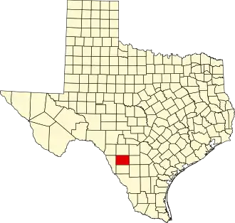 | |
| CDPs | ||