Aptakisic, Illinois
Aptakisic, Illinois | |
|---|---|
 Aptakisic  Aptakisic | |
| Coordinates: 42°10′57″N 87°56′50″W / 42.18250°N 87.94722°W | |
| Country | United States |
| State | Illinois |
| County | Lake |
| Township | Vernon |
| Elevation | 686 ft (209 m) |
| Time zone | UTC-6 (Central (CST)) |
| • Summer (DST) | UTC-5 (CDT) |
| Area codes | 847 & 224 |
| GNIS feature ID | 403584[1] |
Aptakisic is an unincorporated community in Lake County, Illinois, United States. Aptakisic is located along Aptakisic Road and the Canadian National Railway; it borders Buffalo Grove to the west and Lincolnshire to the east.[2]
The name Aptakisic is derived from Chief Aptakisic of the Potawatomie tribe; it is one of two unincorporated communities named in his honor, the other being Half Day.[3]
References
- ^ "Aptakisic". Geographic Names Information System. United States Geological Survey, United States Department of the Interior.
- ^ Lake County General Highway Map (PDF) (Map). Illinois Department of Transportation. 2016. Retrieved March 4, 2018.
- ^ staff. "Village History - Village of Lincolnshire". www.lincolnshireil.gov. Retrieved June 21, 2023.
Municipalities and communities of Lake County, Illinois, United States | ||
|---|---|---|
| Cities | 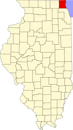 | |
| Villages |
| |
| Townships | ||
| CDPs | ||
| Other unincorporated communities | ||
| Former settlements | ||
| Footnotes | ‡This populated place also has portions in an adjacent county or counties | |