Arros (river)
| Arros | |
|---|---|
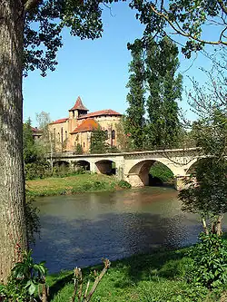 The Arros in Saint-Sever-de-Rustan | |
  | |
| Location | |
| Country | France |
| Physical characteristics | |
| Source | |
| • location | Baronnies of Pyrenees |
| Mouth | |
• location | Adour |
• coordinates | 43°39′44″N 0°1′41″W / 43.66222°N 0.02806°W |
| Length | 130 km (81 mi) |
| Basin size | 947 km2 (366 sq mi) |
| Discharge | |
| • average | 9 m3/s (320 cu ft/s) |
| Basin features | |
| Progression | Adour→ Atlantic Ocean |
The Arros (French pronunciation: [aʁɔs]; Occitan: Arròs) is a right tributary of the Adour, in the Southwest of France. It is 130.2 km (80.9 mi) long.[1]
Name
The name Arros is based on the root Arr- 'stone' and the suffix -os.
Geography
The Arros rises in the Baronnies of Pyrenees, southeast of Bagnères-de-Bigorre, below the Signal de Bassia (1 921 m).
It flows north through a narrow valley defended by the castle of Mauvezin and the bastide of Tournay. It joins the Adour before it turn west, upstream from Riscle.
Départements and towns
- Hautes-Pyrénées: Bourg-de-Bigorre, Tournay, Chelle-Debat
- Gers: Montégut-Arros, Villecomtal-sur-Arros, Plaisance.
Main tributaries
- (L) Esqueda, from Banios
- (L) Luz, from Lies
- (L) Arredou, in Tournay
- (L) Arret Daban or Arret Devant,
- (L) Arret Darré, in Gonez
- (R) Bouès, from Capvern