Asunción Mita
Asunción Mita | |
|---|---|
Municipality and town | |
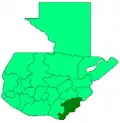
 Asunción Mita Location in Guatemala | |
| Coordinates: 14°20′N 89°43′W / 14.333°N 89.717°W | |
| Country | |
| Department | |
| Area | |
• Total | 195 sq mi (506 km2) |
| Population (2018 census)[1] | |
• Total | 48,297 |
| • Density | 250/sq mi (95/km2) |
| Climate | Aw |
Asunción Mita (Spanish pronunciation: [asunˈsjom ˈmita]) is a town, with a population of 20,936 (2018),[2] and a municipality in the Jutiapa department of Guatemala.
14°20′N 89°43′W / 14.333°N 89.717°W
Population
As of 1850, the population was approximately 3,300.[3]
Festivals
In Asunción Mita two titular celebrations are celebrated: first from the 12th to 15 August, in honor to the Virgin of Asunción; and second from 6 to 12 December, in honor to the Virgin of Concepción. Also, they celebrate in honor to the Flower War on 7 August.
Sports
Deportivo Mictlán football club, will play the 2010/2011 season at the highest level of Guatemalan football, the Liga Mayor. They play their home games at the Estadio La Asunción.
Climate
Asunción Mita has a tropical savanna climate (Köppen: Aw) characterized by hot temperatures and distinct wet and dry seasons. The wet season lasts from May to October, while the dry season lasts for the rest of the year.
| Climate data for Asunción Mita (1991–2020) | |||||||||||||
|---|---|---|---|---|---|---|---|---|---|---|---|---|---|
| Month | Jan | Feb | Mar | Apr | May | Jun | Jul | Aug | Sep | Oct | Nov | Dec | Year |
| Record high °C (°F) | 37.2 (99.0) |
38.8 (101.8) |
39.8 (103.6) |
40.8 (105.4) |
39.4 (102.9) |
37.8 (100.0) |
37.8 (100.0) |
38.4 (101.1) |
37.2 (99.0) |
37.5 (99.5) |
36.8 (98.2) |
37.8 (100.0) |
40.8 (105.4) |
| Mean daily maximum °C (°F) | 33.2 (91.8) |
34.5 (94.1) |
35.6 (96.1) |
36.4 (97.5) |
35.1 (95.2) |
33.6 (92.5) |
34.0 (93.2) |
34.0 (93.2) |
33.3 (91.9) |
32.9 (91.2) |
32.7 (90.9) |
32.9 (91.2) |
34.0 (93.2) |
| Daily mean °C (°F) | 26.1 (79.0) |
27.2 (81.0) |
28.3 (82.9) |
29.5 (85.1) |
28.7 (83.7) |
27.5 (81.5) |
27.9 (82.2) |
27.7 (81.9) |
26.8 (80.2) |
26.6 (79.9) |
26.3 (79.3) |
26.0 (78.8) |
27.4 (81.3) |
| Mean daily minimum °C (°F) | 19.7 (67.5) |
20.2 (68.4) |
21.0 (69.8) |
22.2 (72.0) |
22.5 (72.5) |
21.9 (71.4) |
22.1 (71.8) |
21.9 (71.4) |
21.4 (70.5) |
21.3 (70.3) |
20.7 (69.3) |
20.0 (68.0) |
21.2 (70.2) |
| Record low °C (°F) | 13.0 (55.4) |
13.2 (55.8) |
14.6 (58.3) |
16.3 (61.3) |
17.9 (64.2) |
16.9 (62.4) |
18.2 (64.8) |
18.4 (65.1) |
18.4 (65.1) |
15.4 (59.7) |
12.4 (54.3) |
12.8 (55.0) |
12.4 (54.3) |
| Average precipitation mm (inches) | 0.5 (0.02) |
3.9 (0.15) |
6.5 (0.26) |
34.7 (1.37) |
183.6 (7.23) |
276.4 (10.88) |
197.8 (7.79) |
225.3 (8.87) |
284.6 (11.20) |
164.1 (6.46) |
30.6 (1.20) |
5.6 (0.22) |
1,413.6 (55.65) |
| Average precipitation days (≥ 1.0 mm) | 0.2 | 0.6 | 0.9 | 2.8 | 10.3 | 15.6 | 12.7 | 14.3 | 17.7 | 11.0 | 2.4 | 0.7 | 89.2 |
| Source: NOAA[4] | |||||||||||||
References
- ^ Citypopulation.de Population of departments and municipalities in Guatemala
- ^ Citypopulation.de Population of cities & towns in Guatemala
- ^ Baily, John (1850). Central America; Describing Each of the States of Guatemala, Honduras, Salvador, Nicaragua, and Costa Rica. London: Trelawney Saunders. p. 88.
- ^ "World Meteorological Organization Climate Normals for 1991-2020 — Asunción Mita". National Oceanic and Atmospheric Administration. Retrieved 1 February 2024.