Auburn railway station, Sydney
Auburn | ||||||||||||||||
|---|---|---|---|---|---|---|---|---|---|---|---|---|---|---|---|---|
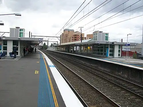 Westbound view from Platform 3 showing shelters and buildings, January 2008 | ||||||||||||||||
| General information | ||||||||||||||||
| Location | Rawson Street, Auburn Australia | |||||||||||||||
| Coordinates | 33°50′58″S 151°01′58″E / 33.84930556°S 151.03285°E | |||||||||||||||
| Owned by | Transport Asset Manager of New South Wales | |||||||||||||||
| Operated by | Sydney Trains | |||||||||||||||
| Line(s) | Main Suburban | |||||||||||||||
| Distance | 18.63 kilometres (11.58 mi) from Central | |||||||||||||||
| Platforms | 4 (2 island) | |||||||||||||||
| Tracks | 4 | |||||||||||||||
| Connections | ||||||||||||||||
| Construction | ||||||||||||||||
| Structure type | Elevated | |||||||||||||||
| Accessible | Yes | |||||||||||||||
| Other information | ||||||||||||||||
| Status | Staffed | |||||||||||||||
| Station code | AUB | |||||||||||||||
| Website | Transport for NSW | |||||||||||||||
| History | ||||||||||||||||
| Opened | 1877 | |||||||||||||||
| Rebuilt | 1913 1954 | |||||||||||||||
| Electrified | Yes | |||||||||||||||
| Passengers | ||||||||||||||||
| 2023[2] |
| |||||||||||||||
| Services | ||||||||||||||||
| ||||||||||||||||
| ||||||||||||||||
Auburn railway station is located on the Main Suburban line, serving the Sydney suburb of Auburn. It is served by Sydney Trains T1 Western and T2 Leppington & Inner West line services. The station serves one of the most multi-culturally diverse suburbs in the city.
To the west of the station lies Auburn Railway Signal Box, UGL Unipart's Maintrain maintenance facility, the Auburn Maintenance Centre and a Pacific National depot.
History
Auburn station opened in 1877.[3] The station was rebuilt in 1913 and again in 1954 when the line was quadrupled.[4]
The original subway underneath the platforms was closed in the 1990s, replaced by a new subway further east, which remains in use to this day.
The station was upgraded in 2007 with new lifts and tiling by Haslin Constructions for RailCorp at a cost of $5.5 million.[5]
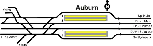
Platforms and services
| Platform | Line | Stopping pattern | Notes |
| 1 | occasional early morning & late night services to Hornsby & Berowra via Central & Chatswood | infrequently used[6] | |
|---|---|---|---|
| 2 | weekday early morning & late night services to Penrith | infrequently used[6] | |
| 3 | weekend services to North Sydney, Chatswood and Lindfield via Central | [6] | |
| services to the City Circle | [7] | ||
| 4 | weekend services to Penrith | [6] | |
| weekday services to Parramatta services to Leppington | [7] |
Transport links
Busways operates two bus routes via Auburn station, under contract to Transport for NSW:
- 540: to Silverwater Correctional Complex[8]
- 544: to Macquarie Centre[9]
Transdev NSW operates four bus routes via Auburn station, under contract to Transport for NSW:
- 908: Merrylands to Bankstown[10]
- 909: Parramatta to Bankstown[11]
- 911: to Bankstown[12]
- S3: to Auburn Botanical Gardens[13]
Auburn railway station is served by two NightRide routes:
- N60: Fairfield station to Town Hall station[14]
- N61: Carlingford station to Town Hall station[15]
Trackplan
References
- ^ This figure is the number of entries and exits of a year combined averaged to a day.
- ^ "Train Station Monthly Usage". Open Data. Retrieved 26 January 2024.
- ^ Auburn Station NSWrail.net
- ^ Auburn Railway Signal Box NSW Environment & Heritage
- ^ [1] Haslin Constructions
- ^ a b c d T1 timetable Transport for NSW
- ^ a b T2 timetable Transport for NSW
- ^ Route 540 timetable Transport for NSW
- ^ Route 544 timetable Transport for NSW
- ^ Route 908 timetable Transport for NSW
- ^ Route 909 timetable Transport for NSW
- ^ Route 911 timetable Transport for NSW
- ^ Route S3 timetable Transport for NSW
- ^ Route N60 timetable Transport for NSW
- ^ Route N61 timetable Transport for NSW
External links
![]() Media related to Auburn railway station at Wikimedia Commons
Media related to Auburn railway station at Wikimedia Commons
- Auburn station details Transport for NSW
- Auburn Station Public Transport Map Transport for NSW