Aukena
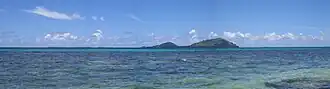 View of Aukena from Mangareva | |
 Aukena | |
| Geography | |
|---|---|
| Location | Pacific Ocean |
| Coordinates | 23°06′42″S 134°54′01″W / 23.11167°S 134.90028°W |
| Archipelago | Tuamotus |
| Area | 1.35 km2 (0.52 sq mi) |
| Length | 2.5 km (1.55 mi) |
| Width | 0.5 km (0.31 mi) |
| Highest elevation | 198 m (650 ft) |
| Highest point | (unnamed) |
| Administration | |
France | |
| Overseas collectivity | French Polynesia |
| Administrative subdivision | Îles Tuamotu-Gambier |
| Commune | Gambier |
| Demographics | |
| Population | 40[1] (2012) |
| Pop. density | 30/km2 (80/sq mi) |
Aukena is the 5th largest of the Gambier Islands in French Polynesia. Aukena is located about halfway between Mangareva and Akamaru, or about 5 km southeast of Mangareva, which is the largest island of the whole Gambier Islands archipelago. Aukena is approximately 2.5 km long and about 0.5 km wide, with a total area of 1.35 km2.
Mangarevan oral tradition first mentions the island in the fourteenth century, and archeological excavations show that it has been inhabited since that time.[2]
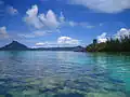
Gallery
-
 Watchtower. Background: Mangareva Island
 -
 Watchtower. Background: Mt. Duff
 -
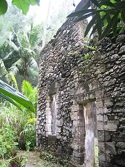 Ruins of Re'e Seminary College, the first college of French Polynesia
 -
 Church of St.Raphael
 -
 Oven for coral lime. Missionaries used it to build various churches in the Gambier Islands.
 -
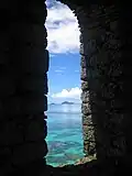 View from the watchtower. View is of Manui and Kamaka
References
- ^ "Population". Institut de la statistique de la Polynésie française. Archived from the original on 11 April 2020. Retrieved 25 September 2014.
- ^ Green, Roger C.; Weisler, Marshall I. (2002). "The Mangarevan Sequence and Dating of the Geographic Expansion into Southeast Polynesia". Asian Perspectives. 41 (2): 225–229. Retrieved 20 December 2022.
Wikimedia Commons has media related to Aukena.
Tuamotus Gambiers | Islands/Atolls | ||
|---|---|---|---|
| Island groups | |||