Avondale, Colorado
Avondale, Colorado | |
|---|---|
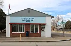 Avondale post office. | |
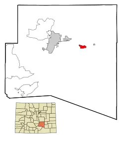 Location of the Avondale CDP in Pueblo County, Colorado. | |
 Avondale Location of Avondale, Colorado.  Avondale Avondale (Colorado) | |
| Coordinates: 38°14′15″N 104°21′04″W / 38.2375°N 104.3511°W[2] | |
| Country | United States |
| State | Colorado |
| County | Pueblo[1] |
| Government | |
| • Type | unincorporated community |
| • Body | Pueblo County[1] |
| Area | |
• Total | 0.628 sq mi (1.627 km2) |
| • Land | 0.628 sq mi (1.627 km2) |
| • Water | 0.000 sq mi (0.000 km2) |
| Elevation | 4,557 ft (1,389 m) |
| Population | |
• Total | 594 |
| • Density | 950/sq mi (370/km2) |
| Time zone | UTC−07:00 (MST) |
| • Summer (DST) | UTC−06:00 (MDT) |
| ZIP Code[4] | 81022 |
| Area code | 719 |
| GNIS pop ID | 204801 |
| GNIS CDP ID | 2407788 |
| FIPS code | 08-04165 |
Avondale is a census-designated place (CDP) and post office located in Pueblo County, Colorado, United States. The CDP is a part of the Pueblo, CO Metropolitan Statistical Area. The Avondale post office has the ZIP Code 81022.[4] At the United States Census 2020, the population of the Avondale CDP was 594, while the population of the 81022 ZIP Code Tabulation Area was 1,624 including adjacent areas.[3]
History
The Avondale, Colorado, post office opened on March 22, 1892.[5] The name Avondale is derived from Stratford-upon-Avon.[6]
Geography
At the 2020 United States census, the Avondale CDP had an area of 402 acres (1.627 km2), all land.[3]
Demographics
| Year | Pop. | ±% |
|---|---|---|
| 2000 | 754 | — |
| 2010 | 674 | −10.6% |
| 2020 | 594 | −11.9% |
| Source: United States Census Bureau | ||
The United States Census Bureau initially defined the Avondale CDP for the United States Census 2000.
Education
It is in the Pueblo County School District 70.[7] Zoned schools include Avondale Elementary School,[8] Vineland Middle School,[9] and Pueblo County High School.[10]
Avondale was first zoned to Pueblo County High in 1953. Prior to that year, its high school was Avondale High School.[11]
See also
- Front Range Urban Corridor
- List of census-designated places in Colorado
- List of populated places in Colorado
- List of post offices in Colorado
- Pueblo, CO Metropolitan Statistical Area
References
- ^ a b "Colorado Counties". Colorado Department of Local Affairs. Retrieved January 20, 2025.
- ^ a b "Avondale, Colorado". Geographic Names Information System. United States Geological Survey, United States Department of the Interior. Retrieved December 31, 2024.
- ^ a b c d "State of Colorado Census Designated Places - BAS20 - Data as of January 1, 2020". United States Census Bureau. Retrieved November 3, 2021.
- ^ a b "Look Up a ZIP Code". United States Postal Service. Retrieved December 26, 2020.
- ^ Bauer, William H.; Ozment, James L.; Willard, John H. (1990). Colorado Post Offices 1859–1989. Golden, Colorado: Colorado Railroad Historical Foundation. ISBN 0-918654-42-4.
- ^ Dawson, John Frank (1954). Place names in Colorado: why 700 communities were so named, 150 of Spanish or Indian origin. Denver, CO: The J. Frank Dawson Publishing Co. p. 8.
- ^ Geography Division (December 17, 2020). 2020 CENSUS - SCHOOL DISTRICT REFERENCE MAP: Pueblo County, CO (PDF) (Map). U.S. Census Bureau. Retrieved 2025-08-04. - Text list
- ^ Pueblo School District No. 70 Elementary School Boundaries (PDF) (Map). Pueblo County School District 70. Retrieved 2025-08-05.
- ^ Pueblo School District No. 70 Middle School Boundaries (PDF) (Map). Pueblo County School District 70. Retrieved 2025-08-05.
- ^ Pueblo School District No. 70 High School Boundaries (PDF) (Map). Pueblo County School District 70. Retrieved 2025-08-05.
- ^ Perez, Gayle (2003-09-28). "County High built after consolidation". The Pueblo Chieftain. Retrieved 2025-08-05.
External links
Municipalities and communities of Pueblo County, Colorado, United States | ||
|---|---|---|
| City |  | |
| Towns | ||
| CDPs | ||
| Unincorporated communities | ||
| Ghost towns | ||