Ayers Island Reservoir
| Ayers Island Reservoir | |
|---|---|
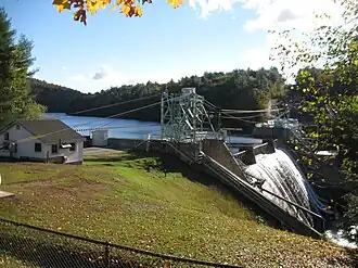 Ayers Island Dam | |
 Ayers Island Reservoir  Ayers Island Reservoir | |
| Location | Grafton County and Belknap County, New Hampshire |
| Coordinates | 43°35′52″N 71°43′04″W / 43.59778°N 71.71778°W |
| Type | Reservoir |
| Primary inflows | Pemigewasset River |
| Primary outflows | Pemigewasset River |
| Basin countries | United States |
| Max. length | 5.5 mi (8.9 km) |
| Max. width | 0.2 mi (0.32 km) |
| Surface elevation | 450 ft (140 m) |
| Settlements | Bristol New Hampton |
The Ayers Island Reservoir is a reservoir located on the Pemigewasset River in central New Hampshire, United States.[1] It occupies the border between the towns of Bristol and New Hampton.
References
- ^ "Evidence for episodic acidification effects on migrating Atlantic salmon Salmo salar smolts" (PDF). US forest service. Retrieved 2025-05-24.