Béthune (river)
| Béthune | |
|---|---|
 | |
| Location | |
| Country | France |
| Region | Normandy |
| Physical characteristics | |
| Source | |
| • location | Gaillefontaine |
| • elevation | 160 m (520 ft) |
| Mouth | |
• location | Arques |
• coordinates | 49°53′29″N 1°7′51″E / 49.89139°N 1.13083°E |
| Length | 61 km (38 mi) |
| Basin size | 307 km2 (119 sq mi) |
| Discharge | |
| • average | 2.9 m3/s (100 cu ft/s) |
| Basin features | |
| Progression | Arques→ English Channel |
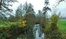
The Béthune (French pronunciation: [betyn] ⓘ) is a river of Normandy, France, 61 kilometres (38 mi) in length, flowing through the department of Seine-Maritime and it is a tributary of the Arques. However, Sandre, the regulators of France's national Water Information System, consider the Béthune to be the upper part of the Arques.[1]
Geography
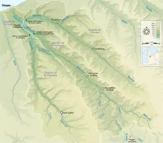
The river's source is at the village of Gaillefontaine near to Forges-les-Eaux. Its valley is wholly within the pays de Bray. Its course takes it past the communes of Neufchâtel-en-Bray, Mesnières-en-Bray, Bures-en-Bray, Osmoy-Saint-Valery, Saint-Vaast-d'Équiqueville, Dampierre-Saint-Nicolas, Saint-Aubin-le-Cauf and finally Arques-la-Bataille where it joins the rivers Eaulne and Varenne to form the Arques.
Like other rivers in the region, the Béthune is classified as a first class river, offering anglers the chance to catch salmon and trout.
See also
References