BR-259 (Brazil highway)
 | |
|---|---|
 | |
 BR-259 between Itueta and Aimorés | |
| Route information | |
| Length | 711.7 km[1] (442.2 mi) |
| Major junctions | |
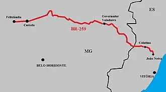
| west end | Felixlândia, Minas Gerais |
| east end | João Neiva, Espírito Santo |
| Location | |
| Country | Brazil |
| Highway system | |
BR-259 is a federal highway in the southeastern Brazil. The road covers 711.7 km from Felixlândia, Minas Gerais to João Neiva, Espírito Santo.[1][2][3]
References
- ^ a b "SNV 2015 Completo". dnit.gov.br (in Portuguese). Departamento Nacional de Infraestrutura de Transportes (DNIT) — Sistema Nacional de Viação. 2015-12-15. Archived from the original on 4 March 2016. Retrieved 28 February 2016.
- ^ "Infra-estrutura de transportes" (map). ibge.gov.br (FTP) (in Portuguese). 2005. Retrieved 28 February 2016. (To view documents see Help:FTP)
- ^ "Rodovias Transversais" (PDF). Archived from the original (PDF) on 2022-01-10. Retrieved 2021-03-13.
| Radial highways (originating from Brasília) | |
|---|---|
| North-south highways | |
| East-west highways | |
| Diagonal highways | |
| Link highways |
|