Bairisch Kölldorf
Bairisch Kölldorf | |
|---|---|
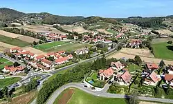 South-southwest view of Bairisch Kölldorf | |
 Coat of arms | |
 Bairisch Kölldorf Location within Austria | |
| Coordinates: 46°52′00″N 15°57′00″E / 46.86667°N 15.95000°E | |
| Country | Austria |
| State | Styria |
| District | Südoststeiermark |
| Area | |
• Total | 6.34 km2 (2.45 sq mi) |
| Elevation | 280 m (920 ft) |
| Population (1 January 2021) | |
• Total | 988 |
| • Density | 160/km2 (400/sq mi) |
| Time zone | UTC+1 (CET) |
| • Summer (DST) | UTC+2 (CEST) |
| Postal code | 8344 |
| Area code | +43 3159 |
| Vehicle registration | SO |
Bairisch Kölldorf is a former municipality in the district of Südoststeiermark in the Austrian state of Styria. Since the 2015 Styria municipal structural reform, it is part of the municipality Bad Gleichenberg.[1]
Geography
The municipality lies about 45 km southeast of Graz and 11 km southeast of Feldbach in the east Styrian hills.
References