Bandarlapalle
Bandarlapalle | |
|---|---|
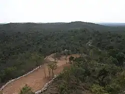 The forests of the Eastern Ghats near Bandarlapalle | |
Dynamic map | |
.svg.png) Bandarlapalle Location in Andhra Pradesh, India | |
| Coordinates: 13°19′51″N 79°5′56″E / 13.33083°N 79.09889°E | |
| Country | India |
| State | Andhra Pradesh |
| District | Chittoor |
| Population (2011)[1] | |
• Total | 6,034 |
| Languages | |
| • Official | Telugu |
| Time zone | UTC+5:30 (IST) |
| Vehicle registration | AP |
Bandarlapalle is a village in the Ramakuppam mandal located in Chittoor district in the Indian state of Andhra Pradesh.[2]
Population
Population (as per the 2011 census) - Total 6,034; 3,087 males; 2,947 females; no. of houses: 1,294
References
- ^ "Census 2011". The Registrar General & Census Commissioner, India. Retrieved 11 November 2014.
- ^ "Mandal wise villages" (PDF). Revenue Department - AP Land. National Informatics Center. p. 22. Archived from the original (pdf) on 14 December 2014. Retrieved 11 November 2014.