Banyumas Regency
Banyumas Regency
Kabupaten Banyumas | |
|---|---|
| Other transcription(s) | |
| • Javanese | ꦧꦚꦸꦩꦱ꧀ |
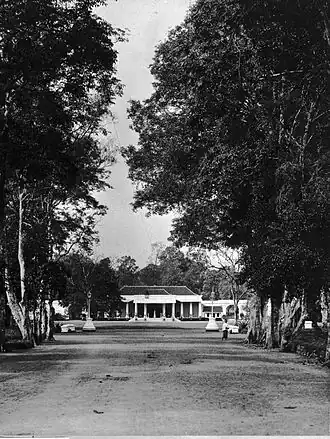
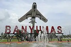 Alun-alun Banyumas | |
 Coat of arms | |
| Motto: Rarasing Rasa Wiwaraning Praja | |
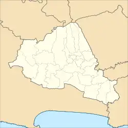
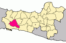 Location within Central Java | |
| Coordinates: 7°36′42″S 109°21′13″E / 7.61167°S 109.35361°E | |
| Country | Indonesia |
| Province | Central Java |
| Capital | Purwokerto |
| Government | |
| • Regent | Sadewo Tri Lastiono |
| • Vice Regent | Dwi Asih Lintarti |
| Area | |
• Total | 1,391.15 km2 (537.13 sq mi) |
| Elevation | 75 m (246 ft) |
| Highest elevation | 3,428 m (11,247 ft) |
| Lowest elevation | 9 m (30 ft) |
| Population (mid 2024 estimate) | |
• Total | 1,847,097 |
| • Density | 1,300/km2 (3,400/sq mi) |
| [1] | |
| Time zone | UTC+7 (IWST) |
| Area code | (+62) 281 |
| Website | banyumaskab.go.id |

Banyumas (Javanese: ꦧꦚꦸꦩꦱ꧀, formerly spelled "Banjoemas") Regency is an inland regency (Indonesian: kabupaten) in the southwestern part of Central Java province in Indonesia. Its capital is the town of Purwokerto, but that town no longer has a central administration and is split over four of the districts within the Regency, with a combined area of 41.65 km2 and a population of 236,162 as of mid-2024.[1] The Regency covers an area of 1,391.15 km2, and had a population of 1,554,527 at the 2010 Census[2] and 1,776,918 at the 2020 Census;[3] the official estimate of the population as of mid-2024 was 1,847,097 (comprising 928,905 males and 918,192 females).[1]
The term Banyumasan is also used as an adjective referring to the culture, language, and peoples of the wider Banyumas area, equivalent to the pre-independence Banyumas Residency. The language of Banyumasan is of Austronesian origin and is usually considered to be a dialect of Javanese.
Administrative districts
Banyumas Regency comprises twenty-seven districts (kecamatan), tabulated below with their areas and their populations at the 2010 Census[2] and the 2020 Census,[3] together with the official estimates as of mid-2024.[1] The table also gives the location of the district administrative centres, the number of administrative villages in each district (totaling 301 rural desa and 30 urban kelurahan), and its postcodes.
| Kode Wilayah |
Name of District (kecamatan) |
Area in km2 |
Pop'n 2010 Census |
Pop'n 2020 Census |
Pop'n mid 2024 estimate |
Admin centre |
No. of villages |
|---|---|---|---|---|---|---|---|
| 33.02.01 | Lumbir[4] | 109.36 | 43,330 | 49,870 | 51,537 | Lumbir | 10 |
| 33.02.02 | Wangon[5] | 60.90 | 73,048 | 83,695 | 86,342 | Wangon | 12 |
| 33.02.03 | Jatilawang[6] | 48.73 | 57,052 | 66,431 | 68,961 | Tunjung | 11 |
| 33.02.04 | Rawalo[7] | 51.48 | 45,268 | 52,847 | 54,915 | Rawalo | 9 |
| 33.02.05 | Kebasen[8] | 52.63 | 55,746 | 67,140 | 70,614 | Gambarsari | 12 |
| 33.02.06 | Kemranjen[9] | 62.90 | 62,385 | 72,383 | 75,037 | Kecila | 15 |
| 33.02.07 | Sumpiuh[10] | 61.96 | 49,790 | 57,717 | 59,812 | Kebokura | 14 (a) |
| 33.02.08 | Tambak [11] | 52.80 | 41,913 | 50,158 | 52,623 | Kamulyan | 12 |
| 33.02.09 | Somagede[12] | 43.70 | 31,827 | 37,540 | 39,165 | Somagede | 9 |
| 33.02.10 | Kalibagor[13] | 40.26 | 45,956 | 56,800 | 60,341 | Kalibagor | 12 |
| 33.02.11 | Banyumas[14] | 41.75 | 45,617 | 52,878 | 54,797 | Sudagaran | 12 |
| 33.02.12 | Patikraja[15] | 45.95 | 50,357 | 60,637 | 63,770 | Notog | 13 |
| 33.02.13 | Purwojati[16] | 41.33 | 30,804 | 36,981 | 38,846 | Purwojati | 10 |
| 33.02.14 | Ajibarang[17] | 69.84 | 89,899 | 102,326 | 105,293 | Ajibarang Kulon | 15 |
| 33.02.15 | Gumelar [18] | 92.40 | 45,154 | 53,349 | 55,694 | Gumelar | 10 |
| 33.02.16 | Pekuncen[19] | 81.10 | 64,424 | 75,576 | 78,681 | Banjaranyar | 16 |
| 33.02.17 | Cilongok[20] | 136.10 | 108,852 | 124,684 | 128,614 | Pernasidi | 20 |
| 33.02.18 | Karanglewas[21] | 33.43 | 57,195 | 67,269 | 70,103 | Karangkemiri | 13 |
| 33.02.23 | Kedungbanteng[22] | 56.34 | 51,118 | 61,771 | 65,051 | Kedungbanteng | 14 |
| 33.02.22 | Baturraden [23] | 45.77 | 47,152 | 53,514 | 55,004 | Rempoah | 12 |
| 33.02.21 | Sumbang [24] | 57.06 | 74,638 | 93,160 | 99,344 | Sumbang | 19 |
| 33.02.20 | Kembaran[25] | 26.64 | 72,148 | 81,737 | 83,955 | Kembaran | 16 |
| 33.02.19 | Sokaraja[26] | 30.28 | 76,903 | 89,184 | 92,436 | Sokaraja Kulon | 18 |
| 33.02.24 | Purwokerto Selatan[27] (South Purwokerto) |
15.58 | 70,519 | 72,304 | 74,928 | Karangklesem | 7 (b) |
| 33.02.25 | Purwokerto Barat[28] (West Purwokerto) |
7.99 | 49,083 | 52,802 | 54,224 | Rejasari | 7 (c) |
| 33.02.26 | Purwokerto Timur[29] (East Purwokerto) |
8.39 | 57,112 | 54,585 | 56,055 | Purwokerto Wetan | 6 (d) |
| 33.02.27 | Purwokerto Utara[30] (North Purwokerto) |
9.69 | 57,237 | 49,580 | 50,955 | Bancarkembar | 7 (e) |
| Totals | 1,391.15 | 1,554,527 | 1,776,918 | 1,847,097 | Purwokerto | 331 |
Notes: (a) including 3 kelurahan - Kebokura, Kradenan and Sumpiuh.
(b) comprising 7 kelurahan - Berkoh, Karangklesem, Karangpucung, Purwokerto Kidul, Purwokerto Kulon, Tanjung and Teluk.
(c) comprising 7 kelurahan - Bantarsoka, Karanglewas Lor, Kedungwuluh, Kober, Pasir Kidul, Pasirmuncang and Rejasari.
(d) comprising 6 kelurahan - Arcawinangun, Kranji, Mersi, Purwokerto Lor, Purwokerto Wetan and Sokanegara.
(e) comprising 7 kelurahan - Bancarkembar, Bobosan, Grendeng, Karangwangkal, Pabuaran, Purwanegara and Sumampir.
Tourism
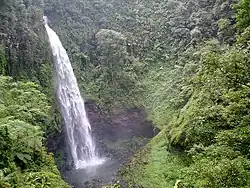
Curug Cipendok is a waterfall 93 metres high, about 15 kilometres west of Purwokerto, 500 metres from the road through a walking trail. It is still natural and is easily accessible on a good road, although there is no public transportation yet. The area surrounding the location belongs to Perhutani, a Forest State Company.[31] North of the capital of Purwokerto, Baturraden Resort features views from the slopes of Mount Slamet.[32] And 8 km to Baturaden, there a Curug Ceheng, this is a waterfall 73 meters, there is an object to holiday.[33]
Among the religious tourism sites in Banyumas is Saka Tunggal Mosque, established in 1871.[34]
References
- ^ a b c d Badan Pusat Statistik, Jakarta, 28 February 2025, Kabupaten Banyumas Dalam Angka 2025 (Katalog-BPS 1102001.3302)
- ^ a b Biro Pusat Statistik, Jakarta, 2011.
- ^ a b Badan Pusat Statistik, Jakarta, 2021.
- ^ Badan Pusat Statistik, Jakarta, 26 September 2024, Kecamatan Lumbir Dalam Angka 2024 (Katalog-BPS 1102001.3302010).
- ^ Badan Pusat Statistik, Jakarta, 26 September 2024, Kecamatan Wangon Dalam Angka 2024 (Katalog-BPS 1102001.3302020).
- ^ Badan Pusat Statistik, Jakarta, 26 September 2024, Kecamatan Jatilawang Dalam Angka 2024 (Katalog-BPS 1102001.3302030).
- ^ Badan Pusat Statistik, Jakarta, 26 September 2024, Kecamatan Rawalo Dalam Angka 2024 (Katalog-BPS 1102001.3302040).
- ^ Badan Pusat Statistik, Jakarta, 26 September 2024, Kecamatan Kebasen Dalam Angka 2024 (Katalog-BPS 1102001.3302050).
- ^ Badan Pusat Statistik, Jakarta, 26 September 2024, Kecamatan Kenranjen Dalam Angka 2024 (Katalog-BPS 1102001.3302060).
- ^ Badan Pusat Statistik, Jakarta, 26 September 2024, Kecamatan Sumpiuh Dalam Angka 2024 (Katalog-BPS 1102001.3302070).
- ^ Badan Pusat Statistik, Jakarta, 26 September 2024, Kecamatan Tambak Dalam Angka 2024 (Katalog-BPS 1102001.3302080).
- ^ Badan Pusat Statistik, Jakarta, 26 September 2024, Kecamatan Somagede Dalam Angka 2024 (Katalog-BPS 1102001.3302090).
- ^ Badan Pusat Statistik, Jakarta, 26 September 2024, Kecamatan Kalibagor Dalam Angka 2024 (Katalog-BPS 1102001.3302100).
- ^ Badan Pusat Statistik, Jakarta, 26 September 2024, Kecamatan Banyumas Dalam Angka 2024 (Katalog-BPS 1102001.3302110).
- ^ Badan Pusat Statistik, Jakarta, 26 September 2024, Kecamatan Patikraja Dalam Angka 2024 (Katalog-BPS 1102001.3302120).
- ^ Badan Pusat Statistik, Jakarta, 26 September 2024, Kecamatan Purwojati Dalam Angka 2024 (Katalog-BPS 1102001.3302130).
- ^ Badan Pusat Statistik, Jakarta, 26 September 2024, Kecamatan Ajibarang Dalam Angka 2024 (Katalog-BPS 1102001.3302140).
- ^ Badan Pusat Statistik, Jakarta, 26 September 2024, Kecamatan Gumelar Dalam Angka 2024 (Katalog-BPS 1102001.3302150).
- ^ Badan Pusat Statistik, Jakarta, 26 September 2024, Kecamatan Pekuncen Dalam Angka 2024 (Katalog-BPS 1102001.3302160).
- ^ Badan Pusat Statistik, Jakarta, 26 September 2024, Kecamatan Cilongok Dalam Angka 2024 (Katalog-BPS 1102001.3302170).
- ^ Badan Pusat Statistik, Jakarta, 26 September 2024, Kecamatan Karanglewas Dalam Angka 2024 (Katalog-BPS 1102001.3302180).
- ^ Badan Pusat Statistik, Jakarta, 26 September 2024, Kecamatan Kedung Banteng Dalam Angka 2024 (Katalog-BPS 1102001.3302190).
- ^ Badan Pusat Statistik, Jakarta, 26 September 2024, Kecamatan Baturraden Dalam Angka 2024 (Katalog-BPS 1102001.3302200).
- ^ Badan Pusat Statistik, Jakarta, 26 September 2024, Kecamatan Sumbang Dalam Angka 2024 (Katalog-BPS 1102001.3302210).
- ^ Badan Pusat Statistik, Jakarta, 26 September 2024, Kecamatan Kembaran Dalam Angka 2024 (Katalog-BPS 1102001.3302220).
- ^ Badan Pusat Statistik, Jakarta, 26 September 2024, Kecamatan Sokaraja Dalam Angka 2024 (Katalog-BPS 1102001.3302230).
- ^ Badan Pusat Statistik, Jakarta, 26 September 2024, Kecamatan Purwokerto Selatan Dalam Angka 2024 (Katalog-BPS 1102001.3302710).
- ^ Badan Pusat Statistik, Jakarta, 26 September 2024, Kecamatan Purwokerto Barat Dalam Angka 2024 (Katalog-BPS 1102001.3302720).
- ^ Badan Pusat Statistik, Jakarta, 26 September 2024, Kecamatan Purwokerto Timur Dalam Angka 2024 (Katalog-BPS 1102001.3302730).
- ^ Badan Pusat Statistik, Jakarta, 26 September 2024, Kecamatan Purwokerto Utara Dalam Angka 2024 (Katalog-BPS 1102001.3302740).
- ^ "Curug Cipendok - Banyumas". Retrieved July 31, 2013.
- ^ "Menyatu Dengan Alam di Wisata Baturaden" [Becoming One with Nature in Baturaden]. Suara Merdeka (in Indonesian). 25 September 2014. Archived from the original on 26 March 2015. Retrieved 26 March 2015.
- ^ "Wisata Curug Cehenk" [Curug Cehenk destination]. Suara Merdeka (in Indonesian). 25 September 2014. Archived from the original on 26 March 2015. Retrieved 29 March 2015.
- ^ Abdulrahman, Robin (17 November 2014). "Minim Fasilitas, Objek Wisata Masjid Saka Tunggal Sepi Pengunjung" [Minimal Facilities, the Tourist Attraction of Saka Tunggal Mosque Lacks Visitors] (in Indonesian). Radio Republik Indonesia. Archived from the original on 2 April 2015. Retrieved 28 March 2015.
External links
- Official site of Banyumas District Government Archived 2020-06-24 at the Wayback Machine (in Indonesian)
Regencies and cities of Central Java | ||
|---|---|---|
Capital: Semarang | ||
| Regencies |  | |
| Cities | ||