Barnard, South Dakota
Barnard | |
|---|---|
 Barnard Location within the state of South Dakota  Barnard Barnard (the United States) | |
| Coordinates: 45°43′57″N 98°29′47″W / 45.73250°N 98.49639°W | |
| Country | United States |
| State | South Dakota |
| County | Brown |
| Area | |
• Total | 7.0000 sq mi (18.1299 km2) |
| Elevation | 1,391 ft (424 m) |
| Population (2000) | |
• Total | 36 |
| • Density | 5.1/sq mi (2.0/km2) |
| Time zone | UTC-6 (Central (CST)) |
| • Summer (DST) | UTC-5 (CDT) |
| ZIP codes | 57426 |
| Area code | 605 |
| GNIS feature ID | 1253773[1] |
Barnard is an unincorporated community in Brown County, South Dakota, United States.[1]
History
Barnard was laid out in 1906, and named for a local resident.[2] A post office was established at Barnard in 1910.[3]
Demographics
The population in Barnard is 36. There are 5 people per square mile. The median age in Barnard is 57.3. The number of people per household in Barnard is 2.1.
References
Municipalities and communities of Brown County, South Dakota, United States | ||
|---|---|---|
| Cities | 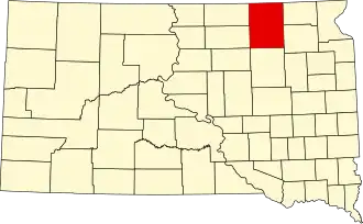 | |
| Towns | ||
| CDPs | ||
| Other communities | ||
| Townships |
| |
| Footnotes | ‡This populated place also has portions in an adjacent county or counties | |