Bennett Springs, Nevada
Bennett Springs, Nevada | |
|---|---|
 Bennett Springs  Bennett Springs | |
| Coordinates: 37°42′51″N 114°28′00″W / 37.71417°N 114.46667°W | |
| Country | United States |
| State | Nevada |
| County | Lincoln |
| Area | |
• Total | 3.39 sq mi (8.77 km2) |
| • Land | 3.39 sq mi (8.77 km2) |
| • Water | 0.00 sq mi (0.00 km2) |
| Elevation | 4,708 ft (1,435 m) |
| Population (2020) | |
• Total | 158 |
| • Density | 46.66/sq mi (18.02/km2) |
| Time zone | UTC-8 (Pacific (PST)) |
| • Summer (DST) | UTC-7 (PDT) |
| ZIP code | 89008[3] |
| Area code | 775 |
| FIPS code | 32-05275 |
| GNIS feature ID | 2583912[2] |
Bennett Springs is a census-designated place in Lincoln County, Nevada, United States. As of the 2010 census it had a population of 132.[4]
Geography
Bennett Springs is located on the western slopes of the Meadow Valley, west of U.S. Route 93, 7 miles (11 km) south of Panaca and 8 miles (13 km) north of Caliente.
According to the U.S. Census Bureau, the Bennett Springs CDP has an area of 3.6 square miles (9.3 km2), all of it land.[5]
Demographics
| Census | Pop. | Note | %± |
|---|---|---|---|
| 2020 | 158 | — | |
| U.S. Decennial Census[6] | |||
References
- ^ "ArcGIS REST Services Directory". United States Census Bureau. Retrieved September 19, 2022.
- ^ a b U.S. Geological Survey Geographic Names Information System: Bennett Springs, Nevada
- ^ "Bennett Springs NV ZIP Code". zipdatamaps.com. 2023. Retrieved June 16, 2023.
- ^ "Total Population: 2010 Census DEC Summary File 1 (P1), Bennett Springs CDP, Nevada". data.census.gov. U.S. Census Bureau. Retrieved May 4, 2020.
- ^ "U.S. Gazetteer Files: 2019: Places: Nevada". U.S. Census Bureau Geography Division. Retrieved May 4, 2020.
- ^ "Census of Population and Housing". Census.gov. Retrieved June 4, 2016.
Municipalities and communities of Lincoln County, Nevada, United States | ||
|---|---|---|
| City | 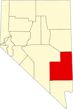 | |
| CDPs | ||
| Other communities | ||
| Ghost towns | ||
| Proposed communities | ||
| Footnotes | ‡This populated place also has portions in an adjacent county or counties | |