Berezan Estuary
| Berezan Estuary | |
|---|---|
 | |
 Berezan Estuary | |
| Location | Black Sea |
| Coordinates | 46°42′N 31°30′E / 46.700°N 31.500°E |
| River sources | Berezan River, Sasyk River |
| Ocean/sea sources | Atlantic Ocean |
| Basin countries | Ukraine |
| Max. length | 26 km (16 mi) |
| Max. width | 0.6–4 km (0.37–2.49 mi) |
| Surface area | 60 km2 (23 sq mi) |
| Average depth | 3.3 m (11 ft) |
| Max. depth | 15 m (49 ft) |
| Water volume | 0.2 km3 (0.048 cu mi) |
| Settlements | Ochakiv |
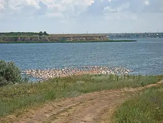
The Berezan Estuary, or Berezanskyi Liman (Ukrainian: Березанський лиман, Turkish: Büzülu liman), is an open estuary on the northern coast of the Black Sea, western from the town Ochakiv.[1] In length of 26 km, and 4 km-wide in south, it is separated from the sea by sandbar, which has a 640-meter canal. Its coasts are high. Two rivers, Berezan and Sasyk, inflow into the estuary.
See also
References