Bigelow, Kansas
Bigelow, Kansas | |
|---|---|
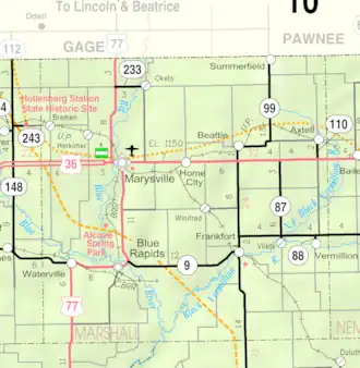 KDOT map of Marshall County (legend) | |
 Bigelow  Bigelow | |
| Coordinates: 39°38′0″N 96°30′16″W / 39.63333°N 96.50444°W[1] | |
| Country | United States |
| State | Kansas |
| County | Marshall |
| Founded | 1881 |
| Named after | Alfred Bigelow |
| Elevation | 1,175 ft (358 m) |
| Population | |
• Total | 0 |
| Time zone | UTC-6 (CST) |
| • Summer (DST) | UTC-5 (CDT) |
| Area code | 785 |
| GNIS ID | 481833 [1] |
Bigelow is a ghost town in Marshall County, Kansas, United States.[1] It was located six and one-half miles southwest of Frankfort.
History
It was founded in 1881[2] and named for General Alfred Bigelow.[3] It was known for its limestone quarries and peaked in population in 1910 at 200.[4]
The post office closed in 1960 and the town was demolished during the construction of Tuttle Creek Lake. All that remains is a historical marker at the intersection of 17th and Zenith Roads and Antioch Cemetery.
References
- ^ a b c d "Bigelow, Kansas", Geographic Names Information System, United States Geological Survey, United States Department of the Interior
- ^ Blackmar, Frank Wilson (1912). Kansas: A Cyclopedia of State History, Embracing Events, Institutions, Industries, Counties, Cities, Towns, Prominent Persons, Etc. Standard Publishing Company. pp. 180.
- ^ Foster, Emma Elizabeth Calderhead (1917). History of Marshall County, Kansas: Its People, Industries, and Institutions. B.F. Bowen. pp. 162.
- ^ Faded Dreams: More Ghost Towns of Kansas by Daniel Fitzgerald. University Press of Kansas. Lawrence, Kansas. 1994
Further reading
External links
Municipalities and communities of Marshall County, Kansas, United States | ||
|---|---|---|
| Cities | 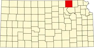 | |
| CDPs | ||
| Unincorporated communities | ||
| Ghost towns | ||
| Townships | ||