Bléone
| Bléone | |
|---|---|
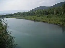 The Bléone at Malijai | |
 | |
| Location | |
| Country | France |
| Physical characteristics | |
| Source | |
| • location | Prads-Haute-Bléone |
| • coordinates | 44°17′00″N 6°31′56″E / 44.2834°N 6.5322°E |
| • elevation | 1,980 m (6,500 ft) |
| Mouth | |
• location | Durance |
• coordinates | 44°03′09″N 05°59′48″E / 44.05250°N 5.99667°E |
• elevation | 400 m (1,300 ft) |
| Length | 69.5 km (43.2 mi) |
| Basin size | 906 km2 (350 sq mi) |
| Basin features | |
| Progression | Durance→ Rhône→ Mediterranean Sea |
The Bléone (French pronunciation: [bleɔn]; Occitan: Blèuna) is a 69.5-kilometre (43.2 mi) long river in the Alpes-de-Haute-Provence département, southeastern France.[1] Its drainage basin is 906 km2 (350 sq mi).[2] Its source is several small streams converging near the refuge de l'Estrop, a mountain shelter in Prads-Haute-Bléone. It flows generally southwest. It is a left tributary of the Durance into which it flows between L'Escale and Les Mées.
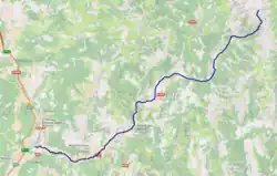
Communes along its course
This list is ordered from source to mouth: Prads-Haute-Bléone, La Javie, Le Brusquet, Marcoux, Digne-les-Bains, Aiglun, Mallemoisson, Le Chaffaut-Saint-Jurson, Mirabeau, Malijai, L'Escale, Les Mées,
References
- ^ Sandre. "Fiche cours d'eau - La Bléone (X12-0400)".
- ^ Bassin versant : Bléone (La), Observatoire Régional Eau et Milieux Aquatiques en PACA
Wikimedia Commons has media related to Bléone.