Black Butte Ranch, Oregon
Black Butte Ranch, Oregon | |
|---|---|
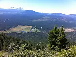
 Black Butte Ranch Lodge with South Sister in background | |
| Coordinates: 44°22′18″N 121°39′10″W / 44.37167°N 121.65278°W | |
| Country | United States |
| State | Oregon |
| County | Deschutes |
| Area | |
• Total | 8.22 sq mi (21.29 km2) |
| • Land | 8.20 sq mi (21.23 km2) |
| • Water | 0.02 sq mi (0.06 km2) |
| Elevation | 3,376 ft (1,029 m) |
| Population | |
• Total | 260 |
| • Density | 31.72/sq mi (12.25/km2) |
| Time zone | UTC-8 (Pacific) |
| • Summer (DST) | UTC-7 (Pacific) |
| ZIP code | 97759 |
| Area code | 541 |
| FIPS code | 41-06650[4] |
| GNIS feature ID | 2584407[3] |
| Website | www |
Black Butte Ranch is a census-designated place (CDP) and unincorporated private resort community[5] in Deschutes County, Oregon, United States.[3] It is located in the Cascade Range, 8 miles (13 km) northwest of Sisters. The population was 366 at the 2010 census.[6] Black Butte Ranch allows public access to its restaurant, golf courses and horse stables, but is primarily oriented to its year-round residents and seasonal guests.[5]
History
The planned community of Black Butte Ranch was developed starting in 1970 by Brooks Resources, a subsidiary of Brooks-Scanlon Lumber Company on the site of the former Black Butte cattle ranch directly south of Black Butte.[7] The first residents arrived in 1971 and Black Butte Ranch post office was established the same year.[7]
Geography
Black Butte Ranch is located in northwestern Deschutes County to the southwest of U.S. Route 20; it is surrounded by Deschutes National Forest. The 6,436-foot (1,962 m) summit of Black Butte overlooks the community to the northeast.
According to the United States Census Bureau, the CDP has a total area of 8.2 square miles (21.3 km2), of which 0.02 square miles (0.06 km2), or 0.29%, is water.[6] The area drains east via Black Butte Swamp to Indian Ford Creek, then Whychus Creek, then to the Deschutes River, a north-flowing tributary of the Columbia River.
Demographics
| Census | Pop. | Note | %± |
|---|---|---|---|
| 2020 | 260 | — | |
| U.S. Decennial Census[8][2] | |||
In 2001, the estimated population of full-time, year-round residents was 337.[5] The population was 366 at the 2010 census.[6] During the peak tourist season, the population, including guests who do not own property but are renting residences within the community, is estimated to rise to 5,000.[5]
Wildfire
Black Butte Ranch has been threatened by many wildfires, especially since 2002, when the Cache Mountain Fire burned two homes in the northwest corner of the ranch.[9][10] Black Butte Ranch was once again threatened by the B&B Complex Fires in 2003,[11] and in 2007 the GW Fire came within a quarter of a mile of some homes on the ranch.[12][13]
Education
It is in the Sisters School District 6.[14]
References
- ^ "ArcGIS REST Services Directory". United States Census Bureau. Retrieved October 12, 2022.
- ^ a b "Census Population API". United States Census Bureau. Retrieved October 12, 2022.
- ^ a b c U.S. Geological Survey Geographic Names Information System: Black Butte Ranch, Oregon
- ^ "U.S. Census website". United States Census Bureau. Retrieved January 31, 2008.
- ^ a b c d Deschutes County Code
- ^ a b c "Geographic Identifiers: 2010 Demographic Profile Data (G001): Black Butte Ranch CDP, Oregon". U.S. Census Bureau, American Factfinder. Archived from the original on February 13, 2020. Retrieved December 11, 2015.
- ^ a b McArthur, Lewis A.; McArthur, Lewis L. (2003) [1928]. Oregon Geographic Names (7th ed.). Portland, Oregon: Oregon Historical Society Press. p. 86. ISBN 978-0875952772.
- ^ "Census of Population and Housing". Census.gov. Retrieved June 4, 2016.
- ^ "BBR residents to return today". Nugget Newspaper. August 2, 2002. Archived from the original on March 3, 2016. Retrieved March 18, 2008.
- ^ "Cache Mountain Fire - Fact Sheet 7". US Forest Service. August 1, 2002. Retrieved March 18, 2008.
- ^ "B and B Complex Morning Brief". US Forest Service. August 21, 2003. Retrieved March 18, 2018.
- ^ "GW Fire: Black Butte Ranch evacuation underway". Nugget Newspaper. September 3, 2007. Archived from the original on November 12, 2017. Retrieved March 18, 2008.
- ^ "Gw Fire Wildland Fire". Incident Information System. September 11, 2007. Archived from the original on June 6, 2008. Retrieved March 18, 2008.
- ^ Geography Division (December 18, 2020). 2020 CENSUS - SCHOOL DISTRICT REFERENCE MAP: Deschutes County, OR (PDF) (Map). U.S. Census Bureau. Retrieved April 3, 2025.
External links
Municipalities and communities of Deschutes County, Oregon, United States | ||
|---|---|---|
| Cities |  | |
| CDPs | ||
| Other communities | ||
| Footnotes | ‡This populated place also has portions in an adjacent county or counties | |