Bohunice, Ilava District
Bohunice | |
|---|---|
 | |
 Flag .png) Coat of arms | |
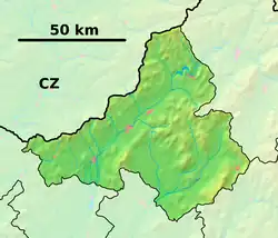 Bohunice Location of Bohunice in the Trenčín Region  Bohunice Location of Bohunice in Slovakia | |
| Coordinates: 49°01′12″N 18°11′44″E / 49.02000°N 18.19556°E | |
| Country | |
| Region | |
| District | Ilava District |
| First mentioned | 1229 |
| Area | |
• Total | 7.04 km2 (2.72 sq mi) |
| Elevation | 241 m (791 ft) |
| Population (2021)[3] | |
• Total | 781 |
| Time zone | UTC+1 (CET) |
| • Summer (DST) | UTC+2 (CEST) |
| Postal code | 185 2[2] |
| Area code | +421 42[2] |
| Car plate | IL |
| Website | www |
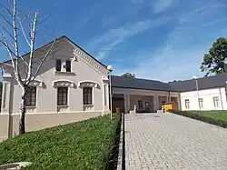
Bohunice (Hungarian: Vágbanya) is a village and municipality in Ilava District in the Trenčín Region of north-western Slovakia.
History
In historical records the village was first mentioned in 1229.
Geography
The municipality lies at an altitude of 276 metres and covers an area of 7.036 km². It has a population of about 752 people.
Genealogical resources
The records for genealogical research are available at the state archive "Statny Archiv in Bratislava, Slovakia"
- Roman Catholic church records (births/marriages/deaths): 1768-1896 (parish A)
See also
References
- ^ "Hustota obyvateľstva - obce [om7014rr_ukaz: Rozloha (Štvorcový meter)]". www.statistics.sk (in Slovak). Statistical Office of the Slovak Republic. 2022-03-31. Retrieved 2022-03-31.
- ^ a b c "Základná charakteristika". www.statistics.sk (in Slovak). Statistical Office of the Slovak Republic. 2015-04-17. Retrieved 2022-03-31.
- ^ "Počet obyvateľov podľa pohlavia - obce (ročne)". www.statistics.sk (in Slovak). Statistical Office of the Slovak Republic. 2022-03-31. Retrieved 2022-03-31.
External links
![]() Media related to Bohunice, Ilava District at Wikimedia Commons
Media related to Bohunice, Ilava District at Wikimedia Commons
Municipalities of Ilava District | ||
|---|---|---|