Bowden, West Virginia
Bowden, West Virginia | |
|---|---|
 Bowden  Bowden | |
| Coordinates: 38°54′31″N 79°42′35″W / 38.90861°N 79.70972°W | |
| Country | United States |
| State | West Virginia |
| County | Randolph |
| Area | |
• Total | 0.124 sq mi (0.32 km2) |
| • Land | 0.124 sq mi (0.32 km2) |
| • Water | 0 sq mi (0 km2) |
| Elevation | 2,215 ft (675 m) |
| Population (2020) | |
• Total | 0 |
| • Density | 0.0/sq mi (0.0/km2) |
| Time zone | UTC-5 (Eastern (EST)) |
| • Summer (DST) | UTC-4 (EDT) |
| ZIP code | 26254 |
| Area codes | 304 & 681 |
| GNIS feature ID | 1550432[2] |
Bowden is a census-designated place (CDP) in Randolph County, West Virginia, United States. Bowden is located on U.S. Route 33, 7.5 miles (12.1 km) east of Elkins. Bowden has a post office with ZIP code 26254.[3] According to the 2020 Census, there were no inhabitants residing at this location (which is down from nine at 2010).[4][5]
References
- ^ "US Gazetteer files: 2010, 2000, and 1990". United States Census Bureau. February 12, 2011. Retrieved April 23, 2011.
- ^ a b U.S. Geological Survey Geographic Names Information System: Bowden, West Virginia
- ^ ZIP Code Lookup Archived June 15, 2011, at the Wayback Machine
- ^ "Census Bureau profile: Bowden CDP, West Virginia". United States Census Bureau. May 2023. Retrieved June 23, 2025.
- ^ "U.S. Census website". United States Census Bureau. Retrieved May 14, 2011.
Municipalities and communities of Randolph County, West Virginia, United States | ||
|---|---|---|
| City | 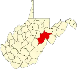 | |
| Towns | ||
| CDPs | ||
| Other communities |
| |
| Ghost towns | ||
| Footnotes | ‡This populated place also has portions in an adjacent county or counties | |