Brandenberg
Brandenberg | |
|---|---|
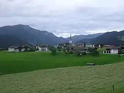 View of Brandenberg | |
 Coat of arms | |
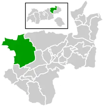 Location within Kufstein district | |
 Brandenberg Location within Austria | |
| Coordinates: 47°30′29″N 11°53′27″E / 47.50806°N 11.89083°E | |
| Country | Austria |
| State | Tyrol |
| District | Kufstein |
| Government | |
| • Mayor | Hans Jürgen Neuhauser |
| Area | |
• Total | 130.17 km2 (50.26 sq mi) |
| Elevation | 919 m (3,015 ft) |
| Population (2018-01-01)[2] | |
• Total | 1,523 |
| • Density | 12/km2 (30/sq mi) |
| Time zone | UTC+1 (CET) |
| • Summer (DST) | UTC+2 (CEST) |
| Postal code | 6234 |
| Area code | 05331 |
| Vehicle registration | KU |
| Website | www.brandenberg. tirol.gv.at |
Brandenberg is a municipality in the Austrian state of Tyrol in the district Kufstein. It consists of the Brandenberg village and the Aschau locality (German: Ortsteil).
Brandenberg was first mentioned in 1140, and became an independent municipality in the beginning of the 19th century. The municipality is located in the valley of the Brandenberger Ache river, a tributary of the Inn River. To the north, it shares a border with Germany. Neighbouring Austrian and German municipalities are Achenkirch, Breitenbach am Inn, Kramsach, Kreuth, Rottach-Egern, Steinberg am Rofan, and Thiersee.
A local specialty is the Prügeltorte cake.
References
- ^ "Dauersiedlungsraum der Gemeinden Politischen Bezirke und Bundesländer - Gebietsstand 1.1.2018". Statistics Austria. Retrieved 10 March 2019.
- ^ "Einwohnerzahl 1.1.2018 nach Gemeinden mit Status, Gebietsstand 1.1.2018". Statistics Austria. Retrieved 9 March 2019.
External links
Wikimedia Commons has media related to Brandenberg (Tirol).