Brectouville
Brectouville | |
|---|---|
Part of Torigny-les-Villes | |
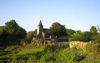 The church of Saint-Pierre | |
Location of Brectouville | |
 Brectouville  Brectouville | |
| Coordinates: 49°01′22″N 1°01′16″W / 49.0228°N 1.0211°W | |
| Country | France |
| Region | Normandy |
| Department | Manche |
| Arrondissement | Saint-Lô |
| Canton | Condé-sur-Vire |
| Commune | Torigny-les-Villes |
Area 1 | 3.74 km2 (1.44 sq mi) |
| Population (2022)[1] | 154 |
| • Density | 41/km2 (110/sq mi) |
| Time zone | UTC+01:00 (CET) |
| • Summer (DST) | UTC+02:00 (CEST) |
| Postal code | 50160 |
| Elevation | 29–137 m (95–449 ft) (avg. 85 m or 279 ft) |
| 1 French Land Register data, which excludes lakes, ponds, glaciers > 1 km2 (0.386 sq mi or 247 acres) and river estuaries. | |
Brectouville (French pronunciation: [bʁɛktuvil]) is a former commune in the Manche department in Normandy in northwestern France. On 1 January 2016, it was merged into the new commune of Torigny-les-Villes.[2]
Population
|
|
See also
References
- ^ "Populations de référence 2022" [Reference populations 2022] (PDF) (in French). INSEE. December 2024.
- ^ Arrêté préfectoral 28 September 2015 (in French)
Wikimedia Commons has media related to Brectouville.