Breitenberg, Lower Bavaria
Breitenberg | |
|---|---|
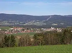 General view of Breitenberg | |
_COA.svg.png) Coat of arms | |
Location of Breitenberg within Passau district 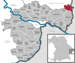 | |
 Breitenberg  Breitenberg | |
| Coordinates: 48°42′N 13°48′E / 48.700°N 13.800°E | |
| Country | Germany |
| State | Bavaria |
| Admin. region | Niederbayern |
| District | Passau |
| Government | |
| • Mayor (2020–26) | Adolf Barth[1] |
| Area | |
• Total | 29.87 km2 (11.53 sq mi) |
| Elevation | 695 m (2,280 ft) |
| Population (2024-12-31)[2] | |
• Total | 1,972 |
| • Density | 66/km2 (170/sq mi) |
| Time zone | UTC+01:00 (CET) |
| • Summer (DST) | UTC+02:00 (CEST) |
| Postal codes | 94139 |
| Dialling codes | 08584 |
| Vehicle registration | PA |
| Website | www.breitenberg.de |
Breitenberg is a municipality in the district of Passau in Bavaria in Germany. It lies on the border with Austria, and is the easternmost municipality of Bavaria.
References
- ^ Liste der ersten Bürgermeister/Oberbürgermeister in kreisangehörigen Gemeinden, Bayerisches Landesamt für Statistik, 15 July 2021.
- ^ "Gemeinden, Kreise und Regierungsbezirke in Bayern, Einwohnerzahlen am 31. Dezember 2024; Basis Zensus 2022" [Municipalities, counties, and administrative districts in Bavaria; Based on the 2022 Census] (CSV) (in German). Bayerisches Landesamt für Statistik.