Brushfield
| Brushfield | |
|---|---|
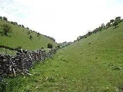 High Dale, Brushfield. | |
 Brushfield parish highlighted within Derbyshire | |
| Population | 13 |
| OS grid reference | SK158714 |
| District | |
| Shire county | |
| Region | |
| Country | England |
| Sovereign state | United Kingdom |
| Post town | BUXTON |
| Postcode district | SK17 |
| Police | Derbyshire |
| Fire | Derbyshire |
| Ambulance | East Midlands |
Brushfield is a hamlet and civil parish in the Derbyshire Dales district of Derbyshire, England, in the Peak District National Park.[1][2] It is about 8 miles east of Buxton. According to the 2001 census it had a population of 13. In 2007 it had just three houses. Several holiday lets are run by two separate families. One of these cottages is called the 'Old School House', a small one-bed house of stone.
There are three scheduled monuments in the parish: bowl barrows at Brushfield Hough[3] and Putwell Hill[4] and High Field hlǣw, a rare pre-Christian burial monument dating from around 600AD.[5]
References
- ^ Ordnance Survey: Landranger map sheet 119 Buxton & Matlock (Chesterfield, Bakewell & Dove Dale) (Map). Ordnance Survey. 2012. ISBN 9780319231890.
- ^ "Ordnance Survey: 1:50,000 Scale Gazetteer" (csv (download)). Ordnance Survey. 1 January 2016. Retrieved 30 January 2016.
- ^ Historic England. "Brushfield Hough bowl barrow (1008814)". National Heritage List for England. Retrieved 12 September 2020.
- ^ Historic England. "Putwell Hill bowl barrow (1008816)". National Heritage List for England. Retrieved 12 September 2020.
- ^ Historic England. "High Field hlaew (1008818)". National Heritage List for England. Retrieved 12 September 2020.
53°14′24″N 1°45′50″W / 53.240°N 1.764°W