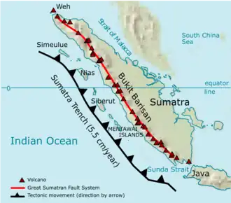
Geological map of Bukit Barisan The Bukit Barisan or the Barisan Mountains are a mountain range on the western side of Sumatra , Indonesia , covering nearly 1,700 km (1,050 mi) from the north to the south of the island. The Bukit Barisan range consists primarily of volcanoes shrouded in dense jungle cover, including Sumatran tropical pine forests on the higher slopes.[ 1] Mount Kerinci at 3,800 metres (12,467 ft).[ 2] Bukit Barisan Selatan National Park is situated towards the southern end of the range in Liwa, Indonesia .
The name Bukit Barisan actually means "row of hills" or "hills that make a row" in Malay , for the range stretches end to end along the island of Sumatra .
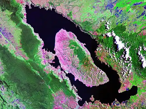
There are 35 active volcanoes in Bukit Barisan. The largest is the supervolcano Toba within the 100 km (62 miles) × 30 km (19 miles) Lake Toba, which was created after a caldera collapse (est. in 74,000 Before Present ).[ 3] VEI scale, the largest possible for a volcanic eruption.
List of volcanoes
The following list of active volcanoes in Bukit Barisan is sourced from the Smithsonian Institution 's Global Volcanism Program.[ 4]
Name
Shape
Elevation
Last eruption (VEI )
Geolocation
Weh stratovolcano Pleistocene 5°49′N 95°17′E / 5.82°N 95.28°E / 5.82; 95.28
Seulawah Agam stratovolcano 1839 (2)5°26′53″N 95°39′29″E / 5.448°N 95.658°E / 5.448; 95.658
Peuet Sague complex volcano 25 December 2000 (2)4°54′50″N 96°19′44″E / 4.914°N 96.329°E / 4.914; 96.329
Geureudong stratovolcano 1937 4°48′47″N 96°49′12″E / 4.813°N 96.82°E / 4.813; 96.82
Mount Leuser non-volcanic
3°44′29″N 97°9′18″E / 3.74139°N 97.15500°E / 3.74139; 97.15500
Kembar shield volcano Pleistocene 3°51′00″N 97°39′50″E / 3.850°N 97.664°E / 3.850; 97.664
Sibayak stratovolcano 1881 3°14′N 98°31′E / 3.23°N 98.52°E / 3.23; 98.52
Sinabung stratovolcano 2 March 2021[ 5]
3°10′12″N 98°23′31″E / 3.17°N 98.392°E / 3.17; 98.392
Toba supervolcano cca 75.000 years ago
2°35′N 98°50′E / 2.58°N 98.83°E / 2.58; 98.83
Helatoba-Tarutung fumarole fieldPleistocene 2°02′N 98°56′E / 2.03°N 98.93°E / 2.03; 98.93
Imun unknown
unknown
2°09′29″N 98°55′48″E / 2.158°N 98.93°E / 2.158; 98.93
Sibualbuali stratovolcano unknown
1°33′22″N 99°15′18″E / 1.556°N 99.255°E / 1.556; 99.255
Lubukraya stratovolcano unknown
1°28′41″N 99°12′32″E / 1.478°N 99.209°E / 1.478; 99.209
Sorikmarapi stratovolcano 1986 (1)0°41′10″N 99°32′20″E / 0.686°N 99.539°E / 0.686; 99.539
Talakmau complex volcano unknown
0°04′44″N 99°58′48″E / 0.079°N 99.98°E / 0.079; 99.98
Sarik-Gajah volcanic cone unknown
unknown
0°00′29″N 100°12′00″E / 0.008°N 100.20°E / 0.008; 100.20
Marapi complex volcano 5 August 2004 (2)0°22′52″S 100°28′23″E / 0.381°S 100.473°E / -0.381; 100.473
Tandikat stratovolcano 1924 (1)0°25′59″S 100°19′01″E / 0.433°S 100.317°E / -0.433; 100.317
Talang stratovolcano 12 April 2005 (2)0°58′41″S 100°40′44″E / 0.978°S 100.679°E / -0.978; 100.679
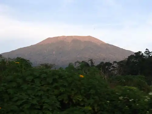
Kerinci stratovolcano 22 June 2004 (2)1°41′49″S 101°15′50″E / 1.697°S 101.264°E / -1.697; 101.264
Hutapanjang stratovolcano unknown
2°20′S 101°36′E / 2.33°S 101.60°E / -2.33; 101.60
Sumbing stratovolcano 23 May 1921 (2)2°24′50″S 101°43′41″E / 2.414°S 101.728°E / -2.414; 101.728
Kunyit stratovolcano unknown
2°35′31″S 101°37′48″E / 2.592°S 101.63°E / -2.592; 101.63
Pendan unknown
unknown
unknown
2°49′S 102°01′E / 2.82°S 102.02°E / -2.82; 102.02
Belirang-Beriti compound
unknown
2°49′S 102°11′E / 2.82°S 102.18°E / -2.82; 102.18
Bukit Daun stratovolcano unknown
3°23′S 102°22′E / 3.38°S 102.37°E / -3.38; 102.37
Kaba stratovolcano 22 August 2000 (1)3°31′S 102°37′E / 3.52°S 102.62°E / -3.52; 102.62
Dempo stratovolcano October 1994 (1)4°02′S 103°08′E / 4.03°S 103.13°E / -4.03; 103.13
Patah unknown
unknown
4°16′S 103°18′E / 4.27°S 103.30°E / -4.27; 103.30
Bukit Lumut Balai stratovolcano unknown
4°14′S 103°37′E / 4.23°S 103.62°E / -4.23; 103.62
Besar stratovolcano April 1940 (1)4°26′S 103°40′E / 4.43°S 103.67°E / -4.43; 103.67
Suoh caldera 10 July 1933 (4)5°15′S 104°16′E / 5.25°S 104.27°E / -5.25; 104.27
Hulubelu caldera 1836 5°21′S 104°36′E / 5.35°S 104.60°E / -5.35; 104.60
Rajabasa stratovolcano 1798 5°46′48″S 105°37′30″E / 5.78°S 105.625°E / -5.78; 105.625
Inactive volcanoes
The following list is sourced from the Study Archaeology[ 6] [ 4]
See also
References
Authority control databases
International National Other
3°00′S 102°15′E / 3.000°S 102.250°E / -3.000; 102.250