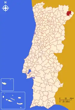
Vimioso
Town of Vimioso | |
|---|---|
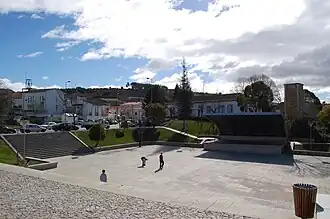 Main square in the centre of Vimioso | |
 Flag  Coat of arms | |
 | |
| Coordinates: 41°35′1″N 6°31′42″W / 41.58361°N 6.52833°W | |
| Country | |
| Region | Norte |
| Intermunic. comm. | Terras de Trás-os-Montes |
| District | Bragança |
| Parishes | 10 (list) |
| Government | |
| • President | José Baptista Rodrigues (PPD-PSD) |
| Area | |
• Total | 481.59 km2 (185.94 sq mi) |
| Elevation | 668 m (2,192 ft) |
| Population (2011) | |
• Total | 4,669 |
| • Density | 9.7/km2 (25/sq mi) |
| Time zone | UTC+00:00 (WET) |
| • Summer (DST) | UTC+01:00 (WEST) |
| Postal code | 5230 |
| Area code | 273 |
| Website | http://www.cm-vimioso.pt |
Vimioso (Portuguese: [vi.miˈo.zu] ⓘ), officially Town of Vimioso (Portuguese: Vila de Vimioso; Mirandese: Bila de Bumioso, Mirandese pronunciation: [βila ðɨ βuˈmjo.z̺ʊ]) is a town and municipality in the district of Bragança in the northern part of Portugal. The population in 2011 was 4,669,[1] in an area of 481.59 km².[2] It is recognised as having a significant number of Mirandese speakers.
In 1516, Vimioso was elevated to the administrative status of a village by order of King Manual I.
Geography
Climate
| Climate data for Pinelo, Vimioso, altitude: 607 m (1,991 ft) | |||||||||||||
|---|---|---|---|---|---|---|---|---|---|---|---|---|---|
| Month | Jan | Feb | Mar | Apr | May | Jun | Jul | Aug | Sep | Oct | Nov | Dec | Year |
| Average precipitation mm (inches) | 81 (3.2) |
71 (2.8) |
47 (1.9) |
51 (2.0) |
59 (2.3) |
32 (1.3) |
12 (0.5) |
10 (0.4) |
34 (1.3) |
75 (3.0) |
84 (3.3) |
83 (3.3) |
639 (25.3) |
| Source: Portuguese Environment Agency[3] | |||||||||||||
Parishes
The municipality is composed of 10 parishes:[4]
- Algoso, Campo de Víboras e Uva
- Caçarelhos e Angueira
- Argozelo
- Carção
- Matela
- Pinelo
- Santulhão
- Vale de Frades e Avelanoso
- Vilar Seco
- Vimioso
-
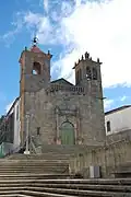 The Romanesque Matriz Church
 -
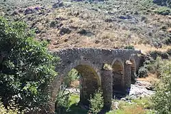 Medieval bridge of Algoso
References
- ^ Instituto Nacional de Estatística
- ^ "Áreas das freguesias, concelhos, distritos e país". Archived from the original on 2018-11-05. Retrieved 2018-11-05.
- ^ "Monthly Precipitation Pinelo". APA. Retrieved 4 June 2021.
- ^ Diário da República. "Law nr. 11-A/2013, page 552 140" (pdf) (in Portuguese). Retrieved 9 July 2014.