Bumpass Mountain
| Bumpass Mountain | |
|---|---|
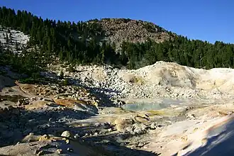 Bumpass Mountain with Bumpass Hell in the foreground | |
| Highest point | |
| Elevation | 8,757 ft (2,669 m) NAVD 88[1] |
| Coordinates | 40°27′41″N 121°29′56″W / 40.4612705°N 121.4988688°W[2] |
| Geography | |
| Location | Lassen Volcanic National Park, Shasta County, California, U.S. |
| Parent range | Cascades |
| Topo map | USGS Reading Peak |
| Geology | |
| Mountain type | Lava dome[3] |
Bumpass Mountain is a mountain located south of Lassen Peak in Lassen Volcanic National Park, California. It rises to an elevation of 8,753 feet (2,668 m) near Bumpass Hell and Lake Helen.[4] The mountain receives heavy snowfall during the winter, which can lead to deep snowpacks of over 300 inches (7.6 m) near the mountain.[5][6]
Both the mountain and Bumpass Hell were named in honor of Kendall V. Bumpass, a hunter, guide and prospector in the area around Red Bluff, California, before 1870.[7]
References
- ^ "Bumpass Mountain, California". Peakbagger.com. Retrieved January 30, 2009.
- ^ "Bumpass Mountain". Geographic Names Information System. United States Geological Survey, United States Department of the Interior. Retrieved January 30, 2009.
- ^ "Global Volcanism Program | Lassen Volcanic Center". Smithsonian Institution | Global Volcanism Program. Retrieved September 10, 2024.
- ^ Reading Peak quadrangle, California (Map). 1:24000. 7.5 Minute Topographic. USGS. Retrieved December 17, 2009.
- ^ "Subsection M261Dm - Lassen - Almanor". USDA, Forest Service. Archived from the original on March 7, 2005. Retrieved November 21, 2007.
- ^ "Cascade Snowfall and Snowdepth". SkiMountaineer.com. Retrieved August 31, 2007.
- ^ Gudde, Erwin G. (1949). California Place Names. Berkeley: Univ. of California Press. p. 44.