Cù Lao Ré volcanic islands
| Cu Lao Re Group | |
|---|---|
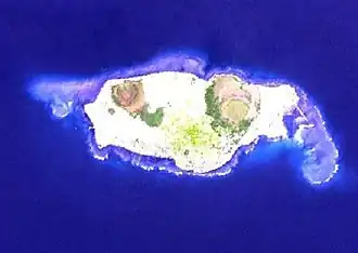 Satellite photo of Cu Lao Re by NASA | |
| Highest point | |
| Elevation | 181 m (594 ft)[1] |
| Coordinates | 15°23′N 109°07′E / 15.38°N 109.12°E |
| Geography | |
| Location | Northeast of Quang Ngai, Vietnam |
| Geology | |
| Rock age | Holocene |
| Mountain type | Volcanic field |
| Last eruption | Unknown |
Cù-Lao Ré is a volcanic field northeast of Quảng Ngãi, Vietnam. The field consists of 13 volcanic cones; four subaerial and nine submarine. Three of the subaerial cones formed the Cù-Lao Ré Island, while the fourth one formed the Cù-Lao Bai Island.[1] The islands form the Lý Sơn District of Quảng Ngãi Province.
See also
References
- ^ a b "Cù-Lao Ré Group". Global Volcanism Program. Smithsonian Institution. Retrieved 2009-08-26.