Cal-Ida, California
Cal-Ida, California | |
|---|---|
 Cal-Ida, California  Cal-Ida, California | |
| Coordinates: 39°31′34″N 121°00′57″W / 39.52611°N 121.01583°W | |
| Country | United States |
| State | California |
| County | Sierra |
| Elevation | 3,537 ft (1,078 m) |
| Time zone | UTC-8 (Pacific (PST)) |
| • Summer (DST) | UTC-7 (PDT) |
| Area code | 530 |
| GNIS feature ID | 1658189[1] |
Cal-Ida is an unincorporated community in Sierra County, California, United States. Cal-Ida is 7 miles (11 km) west of Goodyears Bar.[2] A former sawmill camp, Cal-Ida was down to four residents by 1971;[3] a few buildings remain at the site today.
References
- ^ "US Board on Geographic Names". United States Geological Survey. October 25, 2007. Retrieved January 31, 2008.
- ^ Durham, David L. (1998). California's Geographic Names: A Gazetteer of Historic and Modern Names of the State. Quill Driver Books. p. 459. ISBN 1-884995-14-4.
- ^ "Snowed-in Cal Ida residents rap road policy". The Sacramento Bee. Sacramento, CA. December 30, 1971. Retrieved December 29, 2023.
Municipalities and communities of Sierra County, California, United States | ||
|---|---|---|
| City | 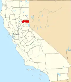 | |
| CDPs | ||
| Unincorporated communities | ||
| Ghost towns | ||