Calavon
| Calavon | |
|---|---|
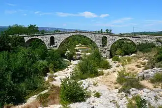 The Calavon crossed by the Pont Julien near Bonnieux | |
 | |
| Location | |
| Country | France |
| Physical characteristics | |
| Source | |
| • location | Banon |
| • coordinates | 44°02′10″N 05°38′32″E / 44.03611°N 5.64222°E |
| • elevation | 420 m (1,380 ft) |
| Mouth | |
• location | Durance |
• coordinates | 43°51′19″N 04°59′16″E / 43.85528°N 4.98778°E |
• elevation | 57 m (187 ft) |
| Length | 86.7 km (53.9 mi) |
| Basin size | 1,027 km2 (397 sq mi) |
| Discharge | |
| • average | 0.89 m3/s (31 cu ft/s) |
| Basin features | |
| Progression | Durance→ Rhône→ Mediterranean Sea |
| Tributaries | |
| • right | Dôa |
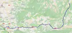
The Calavon (French pronunciation: [kalavɔ̃]; also called le Coulon) is an 86.7-kilometre (53.9 mi) long river in the Alpes-de-Haute-Provence and Vaucluse départements, southeastern France.[1] Its drainage basin is 1,027 km2 (397 sq mi).[2] Its source is near Banon. It flows generally west-southwest. It is a right tributary of the Durance into which it flows at Caumont-sur-Durance, near Cavaillon.
Départements and communes along its course
This list is ordered from source to mouth:
- Alpes-de-Haute-Provence: Banon, Simiane-la-Rotonde, Oppedette,
- Viens, Vaucluse
- Alpes-de-Haute-Provence: Céreste
- Vaucluse: Saint-Martin-de-Castillon, Castellet, Saignon, Caseneuve, Apt, Bonnieux, Roussillon, Goult, Ménerbes, Beaumettes, Oppède, Maubec, Robion, Cavaillon, Caumont-sur-Durance
References
- ^ Sandre. "Fiche cours d'eau - le coulon ou le calavon (X34-0400)".
- ^ Bassin versant : Calavon-Coulon (Le), Observatoire Régional Eau et Milieux Aquatiques en PACA
External links
![]() Media related to Calavon at Wikimedia Commons
Media related to Calavon at Wikimedia Commons