Caleruela
Caleruela | |
|---|---|
 Flag  Coat of arms | |
 | |
| Country | Spain |
| Autonomous community | Castile-La Mancha |
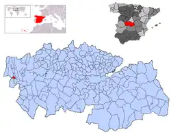
| Province | Toledo |
| Municipality | Caleruela |
| Area | |
• Total | 9 km2 (3 sq mi) |
| Elevation | 322 m (1,056 ft) |
| Population (2018)[1] | |
• Total | 210 |
| • Density | 23/km2 (60/sq mi) |
| Time zone | UTC+1 (CET) |
| • Summer (DST) | UTC+2 (CEST) |
Caleruela is a municipality located in the province of Toledo, Castile-La Mancha, Spain. According to the 2006 census (INE), the municipality has a population of 295 inhabitants.
Demographics
| Year | Pop. | ±% |
|---|---|---|
| 1900 | 491 | — |
| 1910 | 800 | +62.9% |
| 1920 | 815 | +1.9% |
| 1930 | 1,002 | +22.9% |
| 1940 | 1,050 | +4.8% |
| 1950 | 1,119 | +6.6% |
| 1960 | 1,046 | −6.5% |
| 1970 | 649 | −38.0% |
| 1981 | 463 | −28.7% |
| 1991 | 361 | −22.0% |
| 2001 | 296 | −18.0% |
| 2011 | 283 | −4.4% |
| 2021 | 214 | −24.4% |
| 2023 | 202 | −5.6% |
| Source: INE[2][3] | ||
References
- ^ Municipal Register of Spain 2018. National Statistics Institute.
- ^ "Toledo(3078)". INE (in Spanish). Retrieved 2024-02-19.
- ^ "Toledo: Población por municipios y sexo. (2902)". INE (in Spanish). Retrieved 2024-02-19.
39°52′N 5°15′W / 39.867°N 5.250°W