Caneva
Caneva | |
|---|---|
| Comune di Caneva | |
 | |
Location of Caneva | |
 Caneva Location of Caneva in Italy 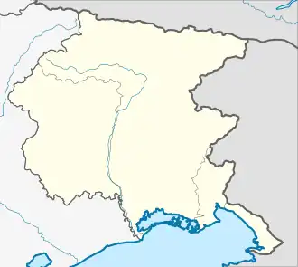 Caneva Caneva (Friuli-Venezia Giulia) | |
| Coordinates: 45°58′N 12°27′E / 45.967°N 12.450°E | |
| Country | Italy |
| Region | Friuli-Venezia Giulia |
| Province | Pordenone (PN) |
| Area | |
• Total | 42.0 km2 (16.2 sq mi) |
| Population (Dec. 2004)[2] | |
• Total | 6,374 |
| • Density | 150/km2 (390/sq mi) |
| Time zone | UTC+1 (CET) |
| • Summer (DST) | UTC+2 (CEST) |
| Postal code | 33070 |
| Dialing code | 0434 |
| Website | Official website |
Caneva (Italian: [ˈkaːneva]; Venetian: Càneva; Standard Friulian: Cjànive, Western Friulian: Cjàneva) is a comune (municipality) in the Regional decentralization entity of Pordenone in the Italian region of Friuli-Venezia Giulia, located about 110 kilometres (68 mi) northwest of Trieste and about 15 kilometres (9 mi) west of Pordenone. As of 31 December 2004, it had a population of 6,374 and an area of 42.0 square kilometres (16.2 sq mi).[3]
Caneva borders the following municipalities: Cordignano, Fontanafredda, Fregona, Polcenigo, Sacile, Sarmede, Tambre.
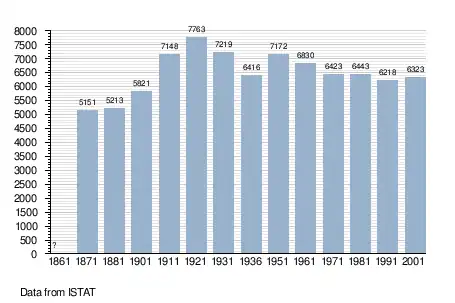
Demographic evolution
Twin towns
Caneva is twinned with:
 Neumarkt-Sankt Veit, Germany, since 2002
Gallery
-
![The Castello di Caneva [it]](./_assets_/Castello_Caneva_01.JPG) The Castello di Caneva
The Castello di Caneva
References
- ^ "Superficie di Comuni Province e Regioni italiane al 9 ottobre 2011". Italian National Institute of Statistics. Retrieved 16 March 2019.
- ^ "Popolazione Residente al 1° Gennaio 2018". Italian National Institute of Statistics. Retrieved 16 March 2019.
- ^ All demographics and other statistics: Italian statistical institute Istat.
External links
Wikimedia Commons has media related to Caneva.