Caravelas
Caravelas | |
|---|---|
 Flag  Coat of arms | |
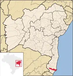 Location in Bahia | |
 Caravelas Location of Caravelas in Brazil | |
| Coordinates: 17°43′55″S 39°15′58″W / 17.732°S 39.266°W | |
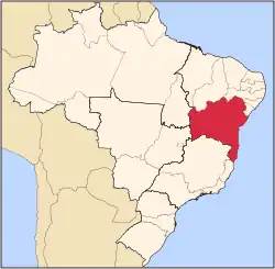
| Country | |
| State | |
| Area | |
• Total | 2,377.889 km2 (918.108 sq mi) |
| Elevation | 10 m (30 ft) |
| Population (2020[1]) | |
• Total | 22,093 |
| • Density | 9.3/km2 (24/sq mi) |
| Time zone | UTC−3 (BRT) |
Caravelas is a city of about 20,000 inhabitants in southern Bahia, Brazil, a few miles above the mouth of the Caravelas River.
Caravelas was founded in 1581 by Portuguese settlers. It was once the centre of a flourishing whale fishery. It is the port of the Bahia-Minas Railway.[2] Caravelas is the nearest town to the uninhabited Abrolhos Archipelago.[3] The city contains part of the Cassurubá Extractive Reserve, a 100,768 hectares (249,000 acres) sustainable use conservation unit that protects an area of mangroves, river and sea where shellfish are harvested.[4]
The city is served by Caravelas Airport.
See also
References
- ^ IBGE 2020
- ^ One or more of the preceding sentences incorporates text from a publication now in the public domain: Chisholm, Hugh, ed. (1911). "Caravellas". Encyclopædia Britannica. Vol. 5 (11th ed.). Cambridge University Press. p. 303.
- ^ O Arquipélago dos Abrolhos Archived 2011-09-10 at the Wayback Machine
- ^ RESEX do Cassurubá (in Portuguese), ISA: Instituto Ambiental, retrieved 2016-06-22
{{citation}}: CS1 maint: publisher location (link)