Carriage Club, Colorado
Carriage Club, Lone Tree, Colorado | |
|---|---|
 Location of Carriage Club in Douglas County, Colorado. | |
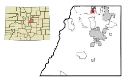
 Carriage Club Location of Carriage Club, Lone Tree, Colorado.  Carriage Club Carriage Club (Colorado) | |
| Coordinates: 39°31′57″N 104°54′04″W / 39.5325°N 104.9011°W[3] | |
| Country | United States |
| State | Colorado |
| County | Douglas[1] |
| City | Lone Tree[2] |
| Government | |
| • Type | neighborhood |
| Elevation | 6,014 ft (1,833 m) |
| Population (2000) | |
• Total | 1,002 |
| Time zone | UTC−07:00 (MST) |
| • Summer (DST) | UTC−06:00 (MDT) |
| ZIP code[4] | Lone Tree 80124 |
| Area codes | 303/720/983 |
| GNIS pop ID | 1852839 |
Carriage Club is a neighborhood in the City of Lone Tree, Douglas County, Colorado, United States. A former census-designated place (CDP), the population was 1,002 at the United States Census 2000.
Geography
Carriage Club is located at coordinates 39°31′57″N 104°54′04″W / 39.5325°N 104.9011°W.[3]
See also
- Denver–Aurora–Centennial, CO Metropolitan Statistical Area
- Front Range Urban Corridor
- List of populated places in Colorado
- List of post offices in Colorado
References
- ^ "Colorado Counties". Colorado Department of Local Affairs. Retrieved May 7, 2025.
- ^ "Active Colorado Municipalities". Colorado Department of Local Affairs. Retrieved May 7, 2025.
- ^ a b c "Carriage Club, Lone Tree, Colorado". Geographic Names Information System. United States Geological Survey, United States Department of the Interior. Retrieved May 7, 2025.
- ^ "ZIP Code Lookup". United States Postal Service. Retrieved May 7, 2025.
External links
Municipalities and communities of Douglas County, Colorado, United States | ||
|---|---|---|
| Cities | 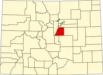 | |
| Towns | ||
| CDPs | ||
| Unincorporated communities | ||
| Ghost towns | ||
| Footnotes | ‡This populated place also has portions in an adjacent county or counties | |