Casella, Liguria
Casella | |
|---|---|
| Comune di Casella | |
 Casella | |
Location of Casella | |
 Casella Location of Casella in Italy 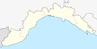 Casella Casella (Liguria) | |
| Coordinates: 44°32′N 9°0′E / 44.533°N 9.000°E | |
| Country | Italy |
| Region | Liguria |
| Metropolitan city | Genoa (GE) |
| Frazioni | Carpeneta, Cortino, Crocetta, Parata-Salvega, Stabbio, Stazione |
| Government | |
| • Mayor | Gabriele Reggiardo |
| Area | |
• Total | 8.07 km2 (3.12 sq mi) |
| Elevation | 410 m (1,350 ft) |
| Population (1-1-2021)[2] | |
• Total | 3,109 |
| • Density | 390/km2 (1,000/sq mi) |
| Demonym | Casellese(i) |
| Time zone | UTC+1 (CET) |
| • Summer (DST) | UTC+2 (CEST) |
| Postal code | 16015 |
| Dialing code | 010 |
| Website | Official website |
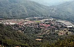
Casella is a comune (municipality) in the Metropolitan City of Genoa in the Italian region of Liguria, about 14 kilometres (9 mi) northeast of Genoa. As of 31 December 2004 it had a population of 3,131 and an area of 7.8 square kilometres (3.0 sq mi).[3]
The municipality of Cassella contains the frazioni (subdivisions, mainly villages and hamlets) of: Carpeneta, Cortino, Crocetta, Parata-Salvega, Stabbio, Stazione.
Casella borders the following municipalities: Montoggio, Savignone, Serra Riccò, Valbrevenna
Casella is the terminus of the Genova–Casella railway.
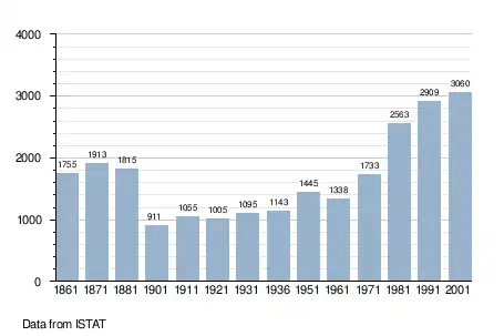
Demographic evolution
References
- ^ "Superficie di Comuni Province e Regioni italiane al 9 ottobre 2011". Italian National Institute of Statistics. Retrieved 16 March 2019.
- ^ "Popolazione Residente al 1° Gennaio 2018". Italian National Institute of Statistics. Retrieved 16 March 2019.
- ^ All demographics and other statistics: Italian statistical institute Istat.
External links