Centum Putei (castra)
| Centum Putei | |
|---|---|
 Location within Romania | |
| Known also as |
|
| Place in the Roman world | |
| Province | Dacia |
| Administrative unit | Dacia Apulensis |
| Administrative unit | Dacia Superior |
| Structure | |
| — Wood and earth structure — | |
| Stationed military units | |
| — Legions — | |
| vexill. IV Flavia Felix | |
| Location | |
| Coordinates | 45°16′25″N 21°35′59″E / 45.273528°N 21.599833°E |
| Altitude | 199 m (653 ft) |
| Place name | Rovină |
| Town | Surducu Mare |
| County | Caraș-Severin |
| Country | |
| Reference | |
| RO-LMI | CS-I-s-B-10877 |
| RO-RAN | 52892.01 |
| UNESCO | |
| Part of | Frontiers of the Roman Empire – Dacia |
| Criteria | Cultural: ii, iii, iv |
| Reference | 1718-004 |
| Inscription | 2024 (46th Session) |
| Site notes | |
| Recognition | |
| Condition | Ruined |
| Archaeologists |
|
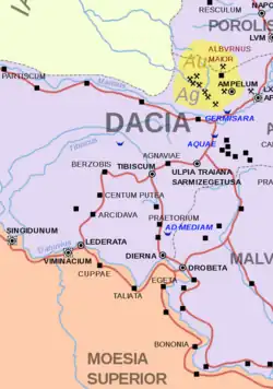
Castra Centum Putei was a Roman fort in the Roman province of Dacia, translated as "a hundred wells/mines/pits".
It is located about 1.5 km NE of the village of Forotic in the place called Rovina. The fort is cut into two equal parts by the Surduc - Doclin road.
The fort was built by the soldiers of the Legio IV Flavia Felix near the pre-existing mining town.
The vicus (civil settlement) included the families of the miners who extracted copper.[3]
See also
External links
- Roman castra from Romania - Google Maps / Earth Archived 2012-12-05 at archive.today
Notes
- ^ Bibliografia lucrărilor științifice ale membrilor Institutului de Istorie din Cluj (1920-2005)
- ^ Centum Putea Archived November 16, 2012, at the Wayback Machine
- ^ Touristic route no. 4: The Romans’ Roads (I) https://banatul-montan.ro/en/the-romans-roads-i/
45°16′24″N 21°35′57″E / 45.27333°N 21.59917°E