Catforth
| Catforth | |
|---|---|
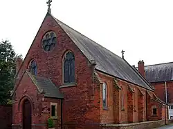 Roman Catholic Church in Catforth | |
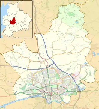 Catforth Shown within the City of Preston district  Catforth Shown on the Fylde  Catforth Location within Lancashire | |
| OS grid reference | SD480354 |
| Civil parish | |
| District | |
| Shire county | |
| Region | |
| Country | England |
| Sovereign state | United Kingdom |
| Post town | PRESTON |
| Postcode district | PR4 |
| Dialling code | 01772 |
| Police | Lancashire |
| Fire | Lancashire |
| Ambulance | North West |
| UK Parliament | |
Catforth is a village in the English civil parish of Woodplumpton and the City of Preston district, in Lancashire, England.[1][2] There is a village hall and the now-closed pub, The Running Pump, is situated on Catforth Road, which is the village's main road. There is a Roman Catholic church and a primary school.
See also
References
- ^ Ordnance Survey: Landranger map sheet 102 Preston & Blackpool (Lytham St Anne's) (Map). Ordnance Survey. 2011. ISBN 9780319228289.
- ^ "Ordnance Survey: 1:50,000 Scale Gazetteer" (csv (download)). www.ordnancesurvey.co.uk. Ordnance Survey. 1 January 2016. Retrieved 30 January 2016.
External links
![]() Media related to Catforth at Wikimedia Commons
Media related to Catforth at Wikimedia Commons
Geography of the City of Preston district | |||||||
|---|---|---|---|---|---|---|---|
| Cities |  | ||||||
| Suburbs | |||||||
| Villages | |||||||
| Parishes | |||||||
| Topography |
| ||||||