Centralia Canal
| Centralia Canal | |
|---|---|
 Centralia Power Canal | |
| Location | Near Yelm, Washington |
| Country | United States |
| Coordinates | 46°55′05″N 122°31′41″W / 46.918°N 122.528°W |
| Specifications | |
| Length | 9 miles (14 km) |
| History | |
| Former names | Centralia Power Canal |
| Date completed | 1929 |
| Geography | |
| End point | Yelm Hydro Project |
| Connects to | Nisqually River |
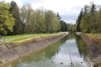
The Centralia Canal, also known as Centralia Power Canal, is a canal in Thurston and Pierce counties, Washington, United States.[1] It is the only feature named a canal in Western Washington.[2] The canal parallels the Nisqually River for 9 miles (14 km) in and around the city of Yelm. It was built in 1929 to supply water for the 12-megawatt Yelm hydroelectric project belonging to the city of Centralia's City Light Department.[3][4]
Part of the canal runs through the Nisqually River Conservation Area, purchased in 2020 by the Nisqually Land Trust.[5][6]
References
- ^ U.S. Geological Survey Geographic Names Information System: Centralia Canal
- ^ U.S. Board on Geographic Names GNIS database, accessed March 16, 2021
- ^ Manning 1995.
- ^ Centralia City Light 2000.
- ^ Current Shoreline Codes : Current Shoreline Designations Map (Map). Thurston County, Washington planning department. March 9, 2021.
- ^ Martín Bilbao (December 20, 2020). "Nisqually River stretch protected by land trust's $1.2 million purchase". The Olympian. Olympia, Washington.
Sources
- Manning, Harvey (1995). Walks & Hikes in the Foothills & Lowlands Around Puget Sound. Mountaineers Books. ISBN 9780898864311.
- "Yelm Hydro Project". Centralia City Light Department. 2000.
Further reading
- Centralia City Light Yelm Hydroelectric Project, Yelm, WA at Pacific Coast Architecture Database, University of Washington Libraries
Wikimedia Commons has media related to Centralia Power Canal.