Cerekvice nad Loučnou
Cerekvice nad Loučnou | |
|---|---|
 Centre of Cerekvice nad Loučnou | |
 Flag  Coat of arms | |
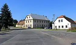
 Cerekvice nad Loučnou Location in the Czech Republic | |
| Coordinates: 49°53′56″N 16°12′55″E / 49.89889°N 16.21528°E | |
| Country | |
| Region | Pardubice |
| District | Svitavy |
| First mentioned | 1167 |
| Area | |
• Total | 8.29 km2 (3.20 sq mi) |
| Elevation | 294 m (965 ft) |
| Population (2025-01-01)[1] | |
• Total | 883 |
| • Density | 110/km2 (280/sq mi) |
| Time zone | UTC+1 (CET) |
| • Summer (DST) | UTC+2 (CEST) |
| Postal codes | 569 53, 570 01 |
| Website | www |
Cerekvice nad Loučnou is a municipality and village in Svitavy District in the Pardubice Region of the Czech Republic. It has about 900 inhabitants.
Cerekvice nad Loučnou lies approximately 25 kilometres (16 mi) north-west of Svitavy, 35 km (22 mi) south-east of Pardubice, and 131 km (81 mi) east of Prague.
Administrative division
Cerekvice nad Loučnou consists of two municipal parts (in brackets population according to the 2021 census):[2]
- Cerekvice nad Loučnou (678)
- Pekla (95)
Demographics
| Year | Pop. | ±% |
|---|---|---|
| 1869 | 737 | — |
| 1880 | 894 | +21.3% |
| 1890 | 982 | +9.8% |
| 1900 | 1,033 | +5.2% |
| 1910 | 1,143 | +10.6% |
| 1921 | 1,137 | −0.5% |
| 1930 | 1,069 | −6.0% |
| 1950 | 829 | −22.5% |
| 1961 | 837 | +1.0% |
| 1970 | 817 | −2.4% |
| 1980 | 773 | −5.4% |
| 1991 | 826 | +6.9% |
| 2001 | 798 | −3.4% |
| 2011 | 819 | +2.6% |
| 2021 | 773 | −5.6% |
| Source: Censuses[3][4] | ||
References
- ^ "Population of Municipalities – 1 January 2025". Czech Statistical Office. 2025-05-16.
- ^ "Public Census 2021 – basic data". Public Database (in Czech). Czech Statistical Office. 2022.
- ^ "Historický lexikon obcí České republiky 1869–2011" (in Czech). Czech Statistical Office. 2015-12-21.
- ^ "Population Census 2021: Population by sex". Public Database. Czech Statistical Office. 2021-03-27.
External links
Wikimedia Commons has media related to Cerekvice nad Loučnou.